Singida geodata
Singida is a seat of a first-order administrative division; located in Tanzania in Africa/Dar_es_Salaam (GMT+3) time zone. With population of 62,432 people, there are 23 cities with bigger population in this country. Compared to other cities in Tanzania, 58.4% of cities are located further ↓South; 56.3% of cities are located further →East and 84.6% of cities have lower elevation than Singida. Note1


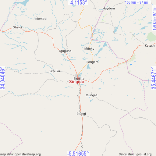
Singida GPS coordinates[2]
4° 48' 58.644" South, 34° 44' 36.888" East
| Map corner | latitude | longitude |
|---|---|---|
| Upper-left | -4.1153°, | 34.04046° |
| Center: | -4.81629°, | 34.74358° |
| Lower-right: | -5.51655°, | 35.44671° |
| Map W x H: | 155.8×155.8 km | = 96.8×96.8mi |
| max Lat: | -1.14389° ⇑41.6% North |
| Singida: | -4.81629° |
| min Lat: | ⇓58.4% South -11.36667° |
| min Long | Singida | max Long |
| 29.62667° | 34.74358° | 40.33333° |
| W 43.7%⇐ | ⇒56.3% E |
Elevation
Elevation of Singida is 1508 m = 4948 ft, and this is 565.2 m = 1854 ft above average elevation for this country.
| Max E: |
2377 m = 7799 ft | 15.4% |
| Singida | 1508 m 4948 ft | |
| Avg. | 942.8 m = 3093 ft | |
Min E: |
0 m = 0 ft | 84.6% |
See also: Singida elevation on elevation.city.
Geographical zone
Singida is located in South Torrid zone (between Equator and Tropic of Capricorn). Distance of Equator is 535.5 km =332.7 mi to North.| Distance of | km | miles | from Singida |
|---|---|---|---|
| Equator | 535.5 | 332.7 | to North |
| Tropic Capricorn | 2070.4 | 1286.5 | to South |
| Antarctic Circle | 6865.7 | 4266.1 | to South |
| South Pole | 9471.5 | 5885.3 | to South |


Nearby cities:
15 places around Singida: (largest is in red/bold)
• Bashanet
98.8 km =61.4 mi,  49°
49°
• Basotu
62.6 km =38.9 mi,  36°
36°
• Endasak
96.5 km =60 mi,  62°
62°
• Igugunu
30.3 km =18.8 mi,  336°
336°
• Ikungi
35.3 km =21.9 mi,  175°
175°
• Ilongero
21.5 km =13.4 mi, 39°
• Katesh
78.1 km =48.5 mi,  65°
65°
• Kiomboi
74 km =46 mi,  325°
325°
• Mtinko
31.9 km =19.8 mi,  21°
21°
• Mungaa
22.8 km =14.2 mi,  137°
137°
• Nangwa
87.4 km =54.3 mi, 63°
• Ndago
49.8 km =30.9 mi,  298°
298°
• Puma
20.5 km =12.7 mi, 183°
• Sepuka
24.4 km =15.2 mi,  287°
287°
• Shelui
78.3 km =48.7 mi,  309°
309°
Sources, notices
• [Note1] Compared only with cities in Tanzania existing in our database
• [Src1] Map data: © OpenStreetMap contributors (CC-BY-SA)
• [Src2] Other city data from geonames.org with taken over terms of usage.
• [Src3] Geographical zone / Annual Mean Temperature by Robert A. Rohde @ Wikipedia
