Endasak geodata
Endasak (Manyara) is a populated place; located in Tanzania in Africa/Dar_es_Salaam (GMT+3) time zone. With population of 14,576 people, there are 187 cities with bigger population in this country. Compared to other cities in Tanzania, 64% of cities are located further ↓South; 52.8% of cities are located further ←West and 89.5% of cities have lower elevation than Endasak. Note1


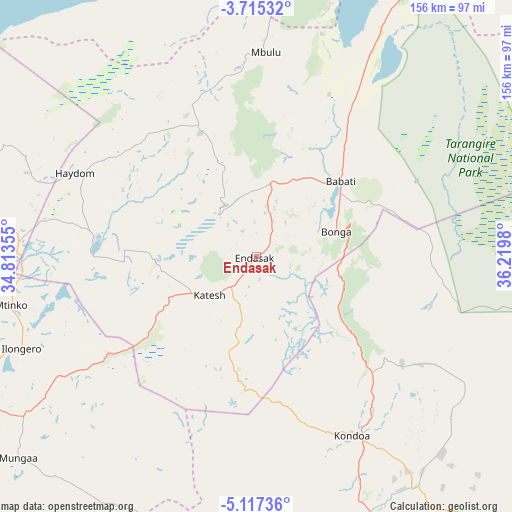
Endasak GPS coordinates[2]
4° 25' 0.012" South, 35° 31' 0.012" East
| Map corner | latitude | longitude |
|---|---|---|
| Upper-left | -3.71532°, | 34.81355° |
| Center: | -4.41667°, | 35.51667° |
| Lower-right: | -5.11736°, | 36.2198° |
| Map W x H: | 155.9×155.9 km | = 96.9×96.9mi |
| max Lat: | -1.14389° ⇑36% North |
| Endasak: | -4.41667° |
| min Lat: | ⇓64% South -11.36667° |
| min Long | Endasak | max Long |
| 29.62667° | 35.51667° | 40.33333° |
| W 52.8%⇐ | ⇒47.2% E |
Elevation
Elevation of Endasak is 1600 m = 5249 ft, and this is 657.2 m = 2156 ft above average elevation for this country.
| Max E: |
2377 m = 7799 ft | 10.5% |
| Endasak | 1600 m 5249 ft | |
| Avg. | 942.8 m = 3093 ft | |
Min E: |
0 m = 0 ft | 89.5% |
See also: Tanzania elevation on elevation.city.
Geographical zone
Endasak is located in South Torrid zone (between Equator and Tropic of Capricorn). Distance of Equator is 491.1 km =305.2 mi to North.| Distance of | km | miles | from Endasak |
|---|---|---|---|
| Equator | 491.1 | 305.2 | to North |
| Tropic Capricorn | 2114.8 | 1314.1 | to South |
| Antarctic Circle | 6910.1 | 4293.7 | to South |
| South Pole | 9516 | 5913 | to South |


Nearby cities:
15 places around Endasak: (largest is in red/bold)
• Babati
34.1 km =21.2 mi,  49°
49°
• Bashanet
23.2 km =14.4 mi,  331°
331°
• Basotu
48.4 km =30.1 mi,  276°
276°
• Dareda
22.5 km =14 mi,  9°
9°
• Dongobesh
41.6 km =25.8 mi,  339°
339°
• Galappo
40.5 km =25.2 mi,  65°
65°
• Ilongero
77.2 km =48 mi,  248°
248°
• Katesh
18.9 km =11.7 mi,  230°
230°
• Kondoa
61.3 km =38.1 mi,  151°
151°
• Magugu
52.4 km =32.6 mi,  31°
31°
• Mbulu
63 km =39.1 mi,  1°
1°
• Mtinko
75.4 km =46.9 mi,  258°
258°
• Mungaa
93.1 km =57.8 mi, 228°
• Nangwa
9.2 km =5.7 mi, 233°
• Singida
96.5 km =60 mi,  242°
242°
Sources, notices
• [Note1] Compared only with cities in Tanzania existing in our database
• [Src1] Map data: © OpenStreetMap contributors (CC-BY-SA)
• [Src2] Other city data from geonames.org with taken over terms of usage.
• [Src3] Geographical zone / Annual Mean Temperature by Robert A. Rohde @ Wikipedia
