Katesh geodata
Katesh (Manyara) is a populated place; located in Tanzania in Africa/Dar_es_Salaam (GMT+3) time zone. With population of 4,943 people, there are 273 cities with bigger population in this country. Compared to other cities in Tanzania, 62.6% of cities are located further ↓South; 51% of cities are located further ←West and 95.5% of cities have lower elevation than Katesh. Note1


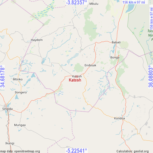
Katesh GPS coordinates[2]
4° 31' 29.388" South, 35° 23' 5.64" East
| Map corner | latitude | longitude |
|---|---|---|
| Upper-left | -3.82357°, | 34.68178° |
| Center: | -4.52483°, | 35.3849° |
| Lower-right: | -5.22541°, | 36.08803° |
| Map W x H: | 155.9×155.9 km | = 96.9×96.9mi |
| max Lat: | -1.14389° ⇑37.4% North |
| Katesh: | -4.52483° |
| min Lat: | ⇓62.6% South -11.36667° |
| min Long | Katesh | max Long |
| 29.62667° | 35.3849° | 40.33333° |
| W 51%⇐ | ⇒49% E |
Elevation
Elevation of Katesh is 1724 m = 5656 ft, and this is 781.2 m = 2563 ft above average elevation for this country.
| Max E: |
2377 m = 7799 ft | 4.5% |
| Katesh | 1724 m 5656 ft | |
| Avg. | 942.8 m = 3093 ft | |
Min E: |
0 m = 0 ft | 95.5% |
See also: Tanzania elevation on elevation.city.
Geographical zone
Katesh is located in South Torrid zone (between Equator and Tropic of Capricorn). Distance of Equator is 503.1 km =312.6 mi to North.| Distance of | km | miles | from Katesh |
|---|---|---|---|
| Equator | 503.1 | 312.6 | to North |
| Tropic Capricorn | 2102.8 | 1306.6 | to South |
| Antarctic Circle | 6898.1 | 4286.3 | to South |
| South Pole | 9503.9 | 5905.4 | to South |


Nearby cities:
15 places around Katesh: (largest is in red/bold)
• Babati
53 km =32.9 mi,  49°
49°
• Bashanet
32.6 km =20.3 mi,  6°
6°
• Basotu
37.8 km =23.5 mi,  297°
297°
• Dareda
38.8 km =24.1 mi,  28°
28°
• Dongobesh
50.9 km =31.6 mi,  359°
359°
• Endasak
18.9 km =11.7 mi, 50°
• Galappo
59 km =36.7 mi,  60°
60°
• Ilongero
59.6 km =37 mi,  254°
254°
• Kondoa
60.7 km =37.7 mi,  133°
133°
• Magugu
70.6 km =43.9 mi,  36°
36°
• Mbulu
76.8 km =47.7 mi, 12°
• Mtinko
59.4 km =36.9 mi,  267°
267°
• Mungaa
74.2 km =46.1 mi,  228°
228°
• Nangwa
9.7 km =6 mi, 48°
• Singida
78.1 km =48.5 mi, 245°
Sources, notices
• [Note1] Compared only with cities in Tanzania existing in our database
• [Src1] Map data: © OpenStreetMap contributors (CC-BY-SA)
• [Src2] Other city data from geonames.org with taken over terms of usage.
• [Src3] Geographical zone / Annual Mean Temperature by Robert A. Rohde @ Wikipedia
