Rovnoye geodata
Rovnoye (Republic of Crimea) is a seat of a third-order administrative division; located in Ukraine in Europe/Simferopol (GMT+3) time zone. With population of 1,399 people, there are 1238 cities with bigger population in this country. Compared to other cities in Ukraine, 81.3% of cities are located further ↑North; 70.7% of cities are located further ←West and 76.5% of cities have higher elevation than Rovnoye. Note1
Administrative division(s):
- Level 1: Republic of Crimea
- Level 2: Krasnohvardiiske Raion
- Level 3: Rovnovskoye sel'skoye poselenye


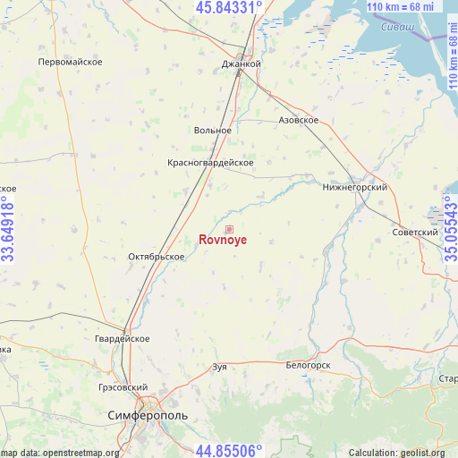
Rovnoye GPS coordinates[2]
45° 21' 4.824" North, 34° 21' 8.28" East
| Map corner | latitude | longitude |
|---|---|---|
| Upper-left | 45.84331°, | 33.64918° |
| Center: | 45.35134°, | 34.3523° |
| Lower-right: | 44.85506°, | 35.05543° |
| Map W x H: | 109.9×109.9 km | = 68.3×68.3mi |
| max Lat: | 52.18903° ⇑81.3% North |
| Rovnoye: | 45.35134° |
| min Lat: | ⇓18.7% South 44.39214° |
| min Long | Rovnoye | max Long |
| 22.20555° | 34.3523° | 40.13222° |
| W 70.7%⇐ | ⇒29.3% E |
Elevation
Elevation of Rovnoye is 55 m = 180 ft, and this is 100.8 m = 331 ft below average elevation for this country.
| Max E: |
886 m = 2907 ft | 76.5% |
| Avg. | 155.8 m = 511 ft | |
| Rovnoye | 55 m = 180 ft | |
Min E: |
-3 m = -10 ft | 23.5% |
See also: Ukraine elevation on elevation.city.
Geographical zone
Rovnoye is located in North temperate zone (between Tropic of Cancer and the Arctic Circle). Distance of this North polar circle is 2358.6 km =1465.6 mi to North.| Distance of | km | miles | from Rovnoye |
|---|---|---|---|
| North Pole | 4964.5 | 3084.8 | to North |
| Arctic Circle | 2358.6 | 1465.6 | to North |
| Tropic Cancer | 2436.7 | 1514.1 | to South |
| Equator | 5042.6 | 3133.3 | to South |


Nearby cities:
15 places around Rovnoye: (largest is in red/bold)
• Kolodeznoye
13.9 km =8.6 mi,  184°
184°
• Komarovka
15.2 km =9.4 mi,  272°
272°
• Krasny Partizan
11.7 km =7.3 mi,  299°
299°
• Mar’yanovka
11.5 km =7.1 mi,  336°
336°
• Mirolyubovka
16.7 km =10.4 mi,  322°
322°
• Molochnoye
4.5 km =2.8 mi,  2°
2°
• Naydenovka
11.7 km =7.3 mi,  139°
139°
• Nekrasovo
9.7 km =6 mi,  327°
327°
• Novopokrovka
11 km =6.8 mi,  44°
44°
• Poltavka
13.2 km =8.2 mi, 269°
• Pyatikhatka
8.2 km =5.1 mi,  247°
247°
• Shcherbakovo
14.7 km =9.1 mi,  359°
359°
• Udachnoye
6.9 km =4.3 mi,  307°
307°
• Yantarnoye
13.8 km =8.6 mi, 312°
• Zernovoye
10.5 km =6.5 mi,  107°
107°
Sources, notices
• [Note1] Compared only with cities in Ukraine existing in our database
• [Src1] Map data: © OpenStreetMap contributors (CC-BY-SA)
• [Src2] Other city data from geonames.org with taken over terms of usage.
• [Src3] Geographical zone / Annual Mean Temperature by Robert A. Rohde @ Wikipedia
