Kolodeznoye geodata
Kolodeznoye (Republic of Crimea) is a seat of a third-order administrative division; located in Ukraine in Europe/Simferopol (GMT+3) time zone. With population of 997 people, there are 1385 cities with bigger population in this country. Compared to other cities in Ukraine, 85.2% of cities are located further ↑North; 70.4% of cities are located further ←West and 58.7% of cities have higher elevation than Kolodeznoye. Note1
Administrative division(s):
- Level 1: Republic of Crimea
- Level 2: Krasnohvardiiske Raion
- Level 3: Kolodezyanskoye sel'skoye poselenye


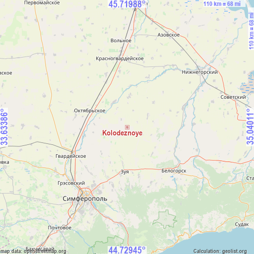
Kolodeznoye GPS coordinates[2]
45° 13' 36.552" North, 34° 20' 13.128" East
| Map corner | latitude | longitude |
|---|---|---|
| Upper-left | 45.71988°, | 33.63386° |
| Center: | 45.22682°, | 34.33698° |
| Lower-right: | 44.72945°, | 35.04011° |
| Map W x H: | 110.1×110.1 km | = 68.4×68.4mi |
| max Lat: | 52.18903° ⇑85.2% North |
| Kolodeznoye: | 45.22682° |
| min Lat: | ⇓14.8% South 44.39214° |
| min Long | Kolodeznoye | max Long |
| 22.20555° | 34.33698° | 40.13222° |
| W 70.4%⇐ | ⇒29.6% E |
Elevation
Elevation of Kolodeznoye is 110 m = 361 ft, and this is 45.8 m = 150 ft below average elevation for this country.
| Max E: |
886 m = 2907 ft | 58.7% |
| Avg. | 155.8 m = 511 ft | |
| Kolodeznoye | 110 m = 361 ft | |
Min E: |
-3 m = -10 ft | 41.3% |
See also: Ukraine elevation on elevation.city.
Geographical zone
Kolodeznoye is located in North temperate zone (between Tropic of Cancer and the Arctic Circle). Distance of this North polar circle is 2372.4 km =1474.1 mi to North.| Distance of | km | miles | from Kolodeznoye |
|---|---|---|---|
| North Pole | 4978.3 | 3093.4 | to North |
| Arctic Circle | 2372.4 | 1474.1 | to North |
| Tropic Cancer | 2422.8 | 1505.5 | to South |
| Equator | 5028.8 | 3124.8 | to South |


Nearby cities:
15 places around Kolodeznoye: (largest is in red/bold)
• Amurskoye
17.3 km =10.7 mi,  289°
289°
• Dolinovka
10.3 km =6.4 mi,  160°
160°
• Klyonovka
16 km =9.9 mi,  224°
224°
• Litvinenkovo
15.7 km =9.8 mi,  187°
187°
• Mel’nichnoye
7.2 km =4.5 mi,  115°
115°
• Naydenovka
10 km =6.2 mi,  60°
60°
• Novozhilovka
11.1 km =6.9 mi,  227°
227°
• Novozuyevka
14.3 km =8.9 mi,  275°
275°
• Oktyabr’skoye
17.2 km =10.7 mi, 293°
• Pyatikhatka
12.5 km =7.8 mi,  329°
329°
• Rovnoye
13.9 km =8.6 mi,  4°
4°
• Rusakovka
15.7 km =9.8 mi,  136°
136°
• Tsvetochnoye
16 km =9.9 mi,  166°
166°
• Verkhnekurgannoye
16.8 km =10.4 mi,  206°
206°
• Zernovoye
15.6 km =9.7 mi,  46°
46°
Sources, notices
• [Note1] Compared only with cities in Ukraine existing in our database
• [Src1] Map data: © OpenStreetMap contributors (CC-BY-SA)
• [Src2] Other city data from geonames.org with taken over terms of usage.
• [Src3] Geographical zone / Annual Mean Temperature by Robert A. Rohde @ Wikipedia
