Zernovoye geodata
Zernovoye (Republic of Crimea) is a seat of a third-order administrative division; located in Ukraine in Europe/Simferopol (GMT+3) time zone. With population of 944 people, there are 1407 cities with bigger population in this country. Compared to other cities in Ukraine, 82.9% of cities are located further ↑North; 59.3% of cities are located further ←West and 66.4% of cities have higher elevation than Zernovoye. Note1
Administrative division(s):
- Level 1: Republic of Crimea
- Level 2: Sakskiy rayon
- Level 3: Zernovskoe sel'skoe poselenie


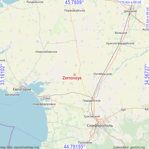
Zernovoye GPS coordinates[2]
45° 17' 18.168" North, 33° 51' 50.904" East
| Map corner | latitude | longitude |
|---|---|---|
| Upper-left | 45.7809°, | 33.16102° |
| Center: | 45.28838°, | 33.86414° |
| Lower-right: | 44.79155°, | 34.56727° |
| Map W x H: | 110×110 km | = 68.4×68.4mi |
| max Lat: | 52.18903° ⇑82.9% North |
| Zernovoye: | 45.28838° |
| min Lat: | ⇓17.1% South 44.39214° |
| min Long | Zernovoye | max Long |
| 22.20555° | 33.86414° | 40.13222° |
| W 59.3%⇐ | ⇒40.7% E |
Elevation
Elevation of Zernovoye is 85 m = 279 ft, and this is 70.8 m = 232 ft below average elevation for this country.
| Max E: |
886 m = 2907 ft | 66.4% |
| Avg. | 155.8 m = 511 ft | |
| Zernovoye | 85 m = 279 ft | |
Min E: |
-3 m = -10 ft | 33.6% |
See also: Ukraine elevation on elevation.city.
Geographical zone
Zernovoye is located in North temperate zone (between Tropic of Cancer and the Arctic Circle). Distance of this North polar circle is 2365.6 km =1469.9 mi to North.| Distance of | km | miles | from Zernovoye |
|---|---|---|---|
| North Pole | 4971.5 | 3089.1 | to North |
| Arctic Circle | 2365.6 | 1469.9 | to North |
| Tropic Cancer | 2429.7 | 1509.7 | to South |
| Equator | 5035.6 | 3129 | to South |


Nearby cities:
15 places around Zernovoye: (largest is in red/bold)
• Dolinka
16.5 km =10.3 mi,  251°
251°
• Il’inka
11.4 km =7.1 mi,  325°
325°
• Kotel’nikovo
15.3 km =9.5 mi,  55°
55°
• Krasnoznamenka
10.7 km =6.6 mi,  90°
90°
• Krayneye
7 km =4.3 mi,  200°
200°
• Krymskoye
12.2 km =7.6 mi, 203°
• Leninskoye
14.7 km =9.1 mi,  98°
98°
• Mityayevo
14.1 km =8.8 mi,  244°
244°
• Shirokoye
17.6 km =10.9 mi,  123°
123°
• Sizovka
6.8 km =4.2 mi,  8°
8°
• Stakhanovka
11.3 km =7 mi,  35°
35°
• Timoshenko
8.6 km =5.3 mi, 88°
• Trudovoye
10 km =6.2 mi, 235°
• Yarkoye
15 km =9.3 mi, 197°
• Zhuravlyovka
16.2 km =10.1 mi,  140°
140°
Sources, notices
• [Note1] Compared only with cities in Ukraine existing in our database
• [Src1] Map data: © OpenStreetMap contributors (CC-BY-SA)
• [Src2] Other city data from geonames.org with taken over terms of usage.
• [Src3] Geographical zone / Annual Mean Temperature by Robert A. Rohde @ Wikipedia
