Stakhanovka geodata
Stakhanovka (Republic of Crimea) is a seat of a third-order administrative division; located in Ukraine in Europe/Simferopol (GMT+3) time zone. With population of 857 people, there are 1457 cities with bigger population in this country. Compared to other cities in Ukraine, 80.7% of cities are located further ↑North; 61.2% of cities are located further ←West and 73.1% of cities have higher elevation than Stakhanovka. Note1
Administrative division(s):
- Level 1: Republic of Crimea
- Level 2: Pervomayskiy rayon
- Level 3: Stakhanovskoye sel'skoye poselenye


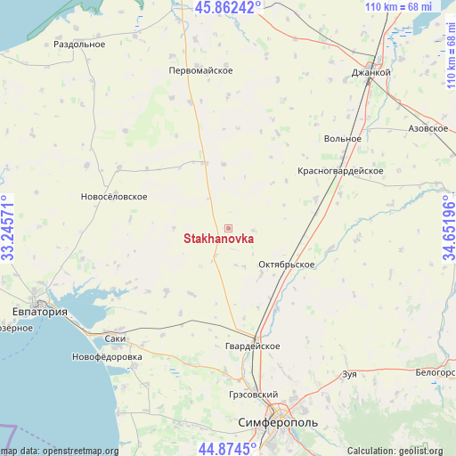
Stakhanovka GPS coordinates[2]
45° 22' 14.232" North, 33° 56' 55.788" East
| Map corner | latitude | longitude |
|---|---|---|
| Upper-left | 45.86242°, | 33.24571° |
| Center: | 45.37062°, | 33.94883° |
| Lower-right: | 44.8745°, | 34.65196° |
| Map W x H: | 109.8×109.8 km | = 68.2×68.2mi |
| max Lat: | 52.18903° ⇑80.7% North |
| Stakhanovka: | 45.37062° |
| min Lat: | ⇓19.3% South 44.39214° |
| min Long | Stakhanovka | max Long |
| 22.20555° | 33.94883° | 40.13222° |
| W 61.2%⇐ | ⇒38.8% E |
Elevation
Elevation of Stakhanovka is 67 m = 220 ft, and this is 88.8 m = 291 ft below average elevation for this country.
| Max E: |
886 m = 2907 ft | 73.1% |
| Avg. | 155.8 m = 511 ft | |
| Stakhanovka | 67 m = 220 ft | |
Min E: |
-3 m = -10 ft | 26.9% |
See also: Ukraine elevation on elevation.city.
Geographical zone
Stakhanovka is located in North temperate zone (between Tropic of Cancer and the Arctic Circle). Distance of this North polar circle is 2356.4 km =1464.2 mi to North.| Distance of | km | miles | from Stakhanovka |
|---|---|---|---|
| North Pole | 4962.3 | 3083.4 | to North |
| Arctic Circle | 2356.4 | 1464.2 | to North |
| Tropic Cancer | 2438.8 | 1515.4 | to South |
| Equator | 5044.7 | 3134.6 | to South |


Nearby cities:
15 places around Stakhanovka: (largest is in red/bold)
• Amurskoye
17.4 km =10.8 mi,  126°
126°
• Chernovo
15.4 km =9.6 mi,  355°
355°
• Dubrovskoye
13.9 km =8.6 mi,  80°
80°
• Il’inka
13.1 km =8.1 mi,  270°
270°
• Komarovka
16.4 km =10.2 mi,  94°
94°
• Kotel’nikovo
6 km =3.7 mi,  95°
95°
• Krasnoznamenka
10.2 km =6.3 mi,  156°
156°
• Kremnevka
15.2 km =9.4 mi,  44°
44°
• Leninskoye
13.9 km =8.6 mi,  145°
145°
• Novoalekseyevka
15.4 km =9.6 mi,  124°
124°
• Oktyabr’skoye
17.2 km =10.7 mi, 122°
• Sizovka
6.1 km =3.8 mi,  246°
246°
• Timoshenko
9.1 km =5.7 mi,  167°
167°
• Voykovo
16.8 km =10.4 mi,  339°
339°
• Zernovoye
11.3 km =7 mi,  215°
215°
Sources, notices
• [Note1] Compared only with cities in Ukraine existing in our database
• [Src1] Map data: © OpenStreetMap contributors (CC-BY-SA)
• [Src2] Other city data from geonames.org with taken over terms of usage.
• [Src3] Geographical zone / Annual Mean Temperature by Robert A. Rohde @ Wikipedia
