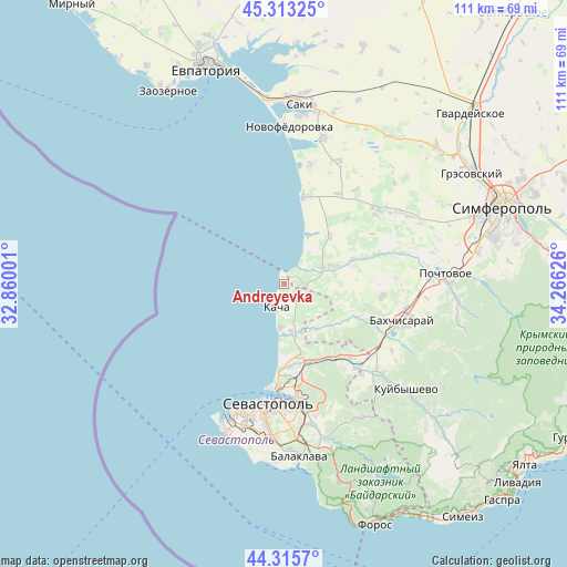
Andreyevka geodata
Andreyevka (Sevastopol City) is a seat of a third-order administrative division; located in Ukraine in Europe/Simferopol (GMT+3) time zone. With population of 1,498 people, there are 1212 cities with bigger population in this country. Compared to other cities in Ukraine, 95.6% of cities are located further ↑North; 52.4% of cities are located further ←West and 85.5% of cities have higher elevation than Andreyevka. Note1
Administrative division(s):
- Level 1: Sevastopol City
- Level 2: Nakhimovskiy rayon
- Level 3: Andreevskiy munitsipal'niy okrug


Andreyevka GPS coordinates[2]
44° 48' 59.868" North, 33° 33' 47.268" East
| Map corner | latitude | longitude |
|---|---|---|
| Upper-left | 45.31325°, | 32.86001° |
| Center: | 44.81663°, | 33.56313° |
| Lower-right: | 44.3157°, | 34.26626° |
| Map W x H: | 110.9×110.9 km | = 68.9×68.9mi |
| max Lat: | 52.18903° ⇑95.6% North |
| Andreyevka: | 44.81663° |
| min Lat: | ⇓4.4% South 44.39214° |
| min Long | Andreyevka | max Long |
| 22.20555° | 33.56313° | 40.13222° |
| W 52.4%⇐ | ⇒47.6% E |
Elevation
Elevation of Andreyevka is 29 m = 95 ft, and this is 126.8 m = 416 ft below average elevation for this country.
| Max E: |
886 m = 2907 ft | 85.5% |
| Avg. | 155.8 m = 511 ft | |
| Andreyevka | 29 m = 95 ft | |
Min E: |
-3 m = -10 ft | 14.5% |
See also: Ukraine elevation on elevation.city.
Geographical zone
Andreyevka is located in North temperate zone (between Tropic of Cancer and the Arctic Circle). Distance of this Northern Tropic circle is 2377.2 km =1477.1 mi to South.| Distance of | km | miles | from Andreyevka |
|---|---|---|---|
| North Pole | 5023.9 | 3121.7 | to North |
| Arctic Circle | 2418 | 1502.5 | to North |
| Tropic Cancer | 2377.2 | 1477.1 | to South |
| Equator | 4983.1 | 3096.4 | to South |


Nearby cities:
15 places around Andreyevka: (largest is in red/bold)
• Beregovoye
10.2 km =6.3 mi,  24°
24°
• Fruktovoye
15.5 km =9.6 mi,  168°
168°
• Furmanovka
15.7 km =9.8 mi,  114°
114°
• Kacha
4.7 km =2.9 mi,  198°
198°
• Orlovka
9.9 km =6.2 mi, 171°
• Otradnoye
14.1 km =8.8 mi,  69°
69°
• Peschanoye
4.7 km =2.9 mi,  50°
50°
• Polyushko
8.5 km =5.3 mi, 166°
• Solnechniy
5.4 km =3.4 mi,  127°
127°
• Suvorovo
10.5 km =6.5 mi,  150°
150°
• Tabachnoye
13 km =8.1 mi,  43°
43°
• Tenistoye
11.6 km =7.2 mi, 134°
• Uglovoye
3.3 km =2.1 mi,  80°
80°
• Vilino
9.1 km =5.7 mi, 69°
• Vishnyovoye
9.9 km =6.2 mi,  160°
160°
Sources, notices
• [Note1] Compared only with cities in Ukraine existing in our database
• [Src1] Map data: © OpenStreetMap contributors (CC-BY-SA)
• [Src2] Other city data from geonames.org with taken over terms of usage.
• [Src3] Geographical zone / Annual Mean Temperature by Robert A. Rohde @ Wikipedia
