Beregovoye geodata
Beregovoye (Republic of Crimea) is a populated place; located in Ukraine in Europe/Simferopol (GMT+3) time zone. With population of 787 people, there are 1493 cities with bigger population in this country. Compared to other cities in Ukraine, 93.3% of cities are located further ↑North; 53.8% of cities are located further ←West and 81.7% of cities have higher elevation than Beregovoye. Note1
Administrative division(s):
- Level 1: Republic of Crimea
- Level 2: Bakhchysarai Raion
- Level 3: Peschanovskoye sel'skoye poselenye


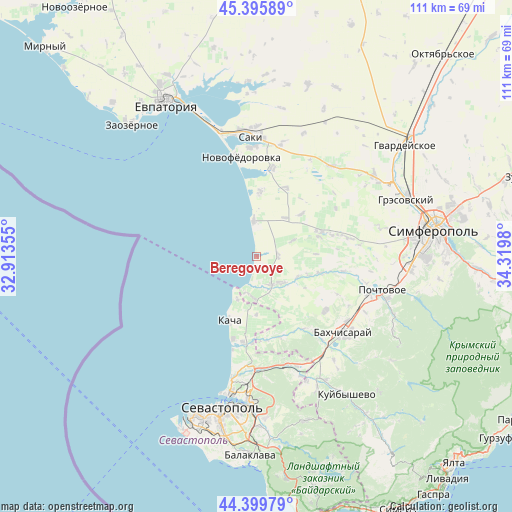
Beregovoye GPS coordinates[2]
44° 54' 0" North, 33° 37' 0.012" East
| Map corner | latitude | longitude |
|---|---|---|
| Upper-left | 45.39589°, | 32.91355° |
| Center: | 44.9°, | 33.61667° |
| Lower-right: | 44.39979°, | 34.3198° |
| Map W x H: | 110.8×110.8 km | = 68.8×68.8mi |
| max Lat: | 52.18903° ⇑93.3% North |
| Beregovoye: | 44.9° |
| min Lat: | ⇓6.7% South 44.39214° |
| min Long | Beregovoye | max Long |
| 22.20555° | 33.61667° | 40.13222° |
| W 53.8%⇐ | ⇒46.2% E |
Elevation
Elevation of Beregovoye is 38 m = 125 ft, and this is 117.8 m = 386 ft below average elevation for this country.
| Max E: |
886 m = 2907 ft | 81.7% |
| Avg. | 155.8 m = 511 ft | |
| Beregovoye | 38 m = 125 ft | |
Min E: |
-3 m = -10 ft | 18.3% |
See also: Ukraine elevation on elevation.city.
Geographical zone
Beregovoye is located in North temperate zone (between Tropic of Cancer and the Arctic Circle). Distance of this Northern Tropic circle is 2386.5 km =1482.9 mi to South.| Distance of | km | miles | from Beregovoye |
|---|---|---|---|
| North Pole | 5014.6 | 3115.9 | to North |
| Arctic Circle | 2408.8 | 1496.8 | to North |
| Tropic Cancer | 2386.5 | 1482.9 | to South |
| Equator | 4992.4 | 3102.1 | to South |


Nearby cities:
15 places around Beregovoye: (largest is in red/bold)
• Andreyevka
10.2 km =6.3 mi,  204°
204°
• Frunze
14.1 km =8.8 mi,  4°
4°
• Kashtany
14.1 km =8.8 mi,  104°
104°
• Nikolayevka
6.9 km =4.3 mi,  356°
356°
• Otradnoye
10 km =6.2 mi,  115°
115°
• Peschanoye
6.3 km =3.9 mi,  185°
185°
• Prudovoye
13 km =8.1 mi,  87°
87°
• Ravnopolye
8.5 km =5.3 mi,  66°
66°
• Razdolye
10.3 km =6.4 mi,  36°
36°
• Shevchenkovo
11.9 km =7.4 mi,  110°
110°
• Solnechniy
12.6 km =7.8 mi,  179°
179°
• Tabachnoye
4.7 km =2.9 mi, 87°
• Uglovoye
8.8 km =5.5 mi, 186°
• Vilino
7.4 km =4.6 mi,  144°
144°
• Vinnitskoye
13.2 km =8.2 mi,  46°
46°
Sources, notices
• [Note1] Compared only with cities in Ukraine existing in our database
• [Src1] Map data: © OpenStreetMap contributors (CC-BY-SA)
• [Src2] Other city data from geonames.org with taken over terms of usage.
• [Src3] Geographical zone / Annual Mean Temperature by Robert A. Rohde @ Wikipedia
