Kulykiv geodata
Kulykiv (Lviv) is a populated place; located in Ukraine in Europe/Kiev (GMT+3) time zone. With population of 3,963 people, there are 769 cities with bigger population in this country. Compared to other cities in Ukraine, 83.3% of cities are located further ↓South; 92.1% of cities are located further →East and 81.9% of cities have lower elevation than Kulykiv. Note1


Kulykiv GPS coordinates[2]
49° 58' 46.344" North, 24° 4' 41.412" East
| Map corner | latitude | longitude |
|---|---|---|
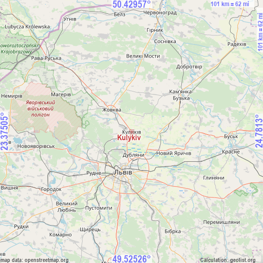
| Upper-left | 50.42957°, | 23.37505° |
| Center: | 49.97954°, | 24.07817° |
| Lower-right: | 49.52526°, | 24.7813° |
| Map W x H: | 100.5×100.5 km | = 62.4×62.4mi |
| max Lat: | 52.18903° ⇑16.7% North |
| Kulykiv: | 49.97954° |
| min Lat: | ⇓83.3% South 44.39214° |
| min Long | Kulykiv | max Long |
| 22.20555° | 24.07817° | 40.13222° |
| W 7.9%⇐ | ⇒92.1% E |
Elevation
Elevation of Kulykiv is 258 m = 846 ft, and this is 102.2 m = 335 ft above average elevation for this country.
| Max E: |
886 m = 2907 ft | 18.1% |
| Kulykiv | 258 m 846 ft | |
| Avg. | 155.8 m = 511 ft | |
Min E: |
-3 m = -10 ft | 81.9% |
See also: Ukraine elevation on elevation.city.
Geographical zone
Kulykiv is located in North temperate zone (between Tropic of Cancer and the Arctic Circle). Distance of this North polar circle is 1844 km =1145.8 mi to North.| Distance of | km | miles | from Kulykiv |
|---|---|---|---|
| North Pole | 4449.9 | 2765 | to North |
| Arctic Circle | 1844 | 1145.8 | to North |
| Tropic Cancer | 2951.3 | 1833.9 | to South |
| Equator | 5557.2 | 3453.1 | to South |


Nearby cities:
15 places around Kulykiv: (largest is in red/bold)
• Bryukhovychi
11.9 km =7.4 mi,  225°
225°
• Dublyany
8.4 km =5.2 mi,  175°
175°
• Godovytsya
26.3 km =16.3 mi,  206°
206°
• Hlyns'k
15.6 km =9.7 mi,  305°
305°
• Ivano-Frankove
25.8 km =16 mi,  255°
255°
• Kamianka-Buzka
23.7 km =14.7 mi,  53°
53°
• Krekhiv
20.4 km =12.7 mi,  293°
293°
• Lviv
16.2 km =10.1 mi,  194°
194°
• Novyi Yarychiv
18.3 km =11.4 mi,  117°
117°
• Obroshyne
26.6 km =16.5 mi, 214°
• Rudne
20.7 km =12.9 mi,  218°
218°
• Solonka
25.3 km =15.7 mi, 191°
• Sukhovolya
24.4 km =15.2 mi, 224°
• Verkhnyaya Belka
24.3 km =15.1 mi,  138°
138°
• Zhovkva
11.6 km =7.2 mi,  319°
319°
Sources, notices
• [Note1] Compared only with cities in Ukraine existing in our database
• [Src1] Map data: © OpenStreetMap contributors (CC-BY-SA)
• [Src2] Other city data from geonames.org with taken over terms of usage.
• [Src3] Geographical zone / Annual Mean Temperature by Robert A. Rohde @ Wikipedia
