Verkhnyaya Belka geodata
Verkhnyaya Belka (Lviv) is a populated place; located in Ukraine in Europe/Kiev (GMT+3) time zone. With population of 1,508 people, there are 1209 cities with bigger population in this country. Compared to other cities in Ukraine, 79.8% of cities are located further ↓South; 90.8% of cities are located further →East and 77.5% of cities have lower elevation than Verkhnyaya Belka. Note1


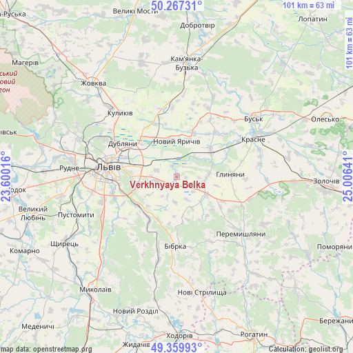
Verkhnyaya Belka GPS coordinates[2]
49° 48' 56.7" North, 24° 18' 11.808" East
| Map corner | latitude | longitude |
|---|---|---|
| Upper-left | 50.26731°, | 23.60016° |
| Center: | 49.81575°, | 24.30328° |
| Lower-right: | 49.35993°, | 25.00641° |
| Map W x H: | 100.9×100.9 km | = 62.7×62.7mi |
| max Lat: | 52.18903° ⇑20.2% North |
| Verkhnyaya Belka: | 49.81575° |
| min Lat: | ⇓79.8% South 44.39214° |
| min Long | Verkhnyaya Belk | max Long |
| 22.20555° | 24.30328° | 40.13222° |
| W 9.2%⇐ | ⇒90.8% E |
Elevation
Elevation of Verkhnyaya Belka is 236 m = 774 ft, and this is 80.2 m = 263 ft above average elevation for this country.
| Max E: |
886 m = 2907 ft | 22.5% |
| Verkhnyaya Belka | 236 m 774 ft | |
| Avg. | 155.8 m = 511 ft | |
Min E: |
-3 m = -10 ft | 77.5% |
See also: Ukraine elevation on elevation.city.
Geographical zone
Verkhnyaya Belka is located in North temperate zone (between Tropic of Cancer and the Arctic Circle). Distance of this North polar circle is 1862.2 km =1157.1 mi to North.| Distance of | km | miles | from Verkhnyaya Belka |
|---|---|---|---|
| North Pole | 4468.1 | 2776.3 | to North |
| Arctic Circle | 1862.2 | 1157.1 | to North |
| Tropic Cancer | 2933.1 | 1822.5 | to South |
| Equator | 5539 | 3441.8 | to South |


Nearby cities:
15 places around Verkhnyaya Belka: (largest is in red/bold)
• Bibrka
19.5 km =12.1 mi,  183°
183°
• Bryukhovychi
26.5 km =16.5 mi,  291°
291°
• Bus’k
27.7 km =17.2 mi,  53°
53°
• Dublyany
18.4 km =11.4 mi,  302°
302°
• Dzvinogrud
9.9 km =6.2 mi,  202°
202°
• Krasne
24.8 km =15.4 mi,  63°
63°
• Kulykiv
24.3 km =15.1 mi,  318°
318°
• Lviv
20.2 km =12.6 mi,  277°
277°
• Navaria
28 km =17.4 mi,  254°
254°
• Novyi Yarychiv
9.9 km =6.2 mi,  0°
0°
• Peremyshlyany
24.8 km =15.4 mi,  132°
132°
• Shpyl’chyna
17 km =10.6 mi,  185°
185°
• Solonka
22.1 km =13.7 mi, 252°
• Staroye Selo
14.3 km =8.9 mi,  214°
214°
• Svirzh
21 km =13 mi,  152°
152°
Sources, notices
• [Note1] Compared only with cities in Ukraine existing in our database
• [Src1] Map data: © OpenStreetMap contributors (CC-BY-SA)
• [Src2] Other city data from geonames.org with taken over terms of usage.
• [Src3] Geographical zone / Annual Mean Temperature by Robert A. Rohde @ Wikipedia
