Dublyany geodata
Dublyany (Lviv) is a populated place; located in Ukraine in Europe/Kiev (GMT+3) time zone. With population of 8,154 people, there are 433 cities with bigger population in this country. Compared to other cities in Ukraine, 81.7% of cities are located further ↓South; 92.1% of cities are located further →East and 81.9% of cities have lower elevation than Dublyany. Note1


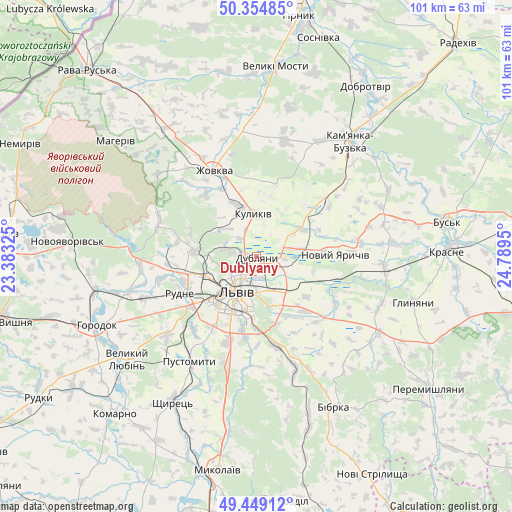
Dublyany GPS coordinates[2]
49° 54' 14.796" North, 24° 5' 10.932" East
| Map corner | latitude | longitude |
|---|---|---|
| Upper-left | 50.35485°, | 23.38325° |
| Center: | 49.90411°, | 24.08637° |
| Lower-right: | 49.44912°, | 24.7895° |
| Map W x H: | 100.7×100.7 km | = 62.6×62.6mi |
| max Lat: | 52.18903° ⇑18.3% North |
| Dublyany: | 49.90411° |
| min Lat: | ⇓81.7% South 44.39214° |
| min Long | Dublyany | max Long |
| 22.20555° | 24.08637° | 40.13222° |
| W 7.9%⇐ | ⇒92.1% E |
Elevation
Elevation of Dublyany is 258 m = 846 ft, and this is 102.2 m = 335 ft above average elevation for this country.
| Max E: |
886 m = 2907 ft | 18.1% |
| Dublyany | 258 m 846 ft | |
| Avg. | 155.8 m = 511 ft | |
Min E: |
-3 m = -10 ft | 81.9% |
See also: Ukraine elevation on elevation.city.
Geographical zone
Dublyany is located in North temperate zone (between Tropic of Cancer and the Arctic Circle). Distance of this North polar circle is 1852.4 km =1151 mi to North.| Distance of | km | miles | from Dublyany |
|---|---|---|---|
| North Pole | 4458.2 | 2770.2 | to North |
| Arctic Circle | 1852.4 | 1151 | to North |
| Tropic Cancer | 2942.9 | 1828.6 | to South |
| Equator | 5548.8 | 3447.9 | to South |


Nearby cities:
15 places around Dublyany: (largest is in red/bold)
• Bryukhovychi
9.1 km =5.7 mi,  270°
270°
• Dzvinogrud
22.3 km =13.9 mi,  148°
148°
• Godovytsya
19.5 km =12.1 mi,  218°
218°
• Hlyns'k
21.9 km =13.6 mi,  322°
322°
• Kulykiv
8.4 km =5.2 mi,  355°
355°
• Lviv
8.6 km =5.3 mi,  211°
211°
• Navaria
20.6 km =12.8 mi, 213°
• Novyi Yarychiv
15.7 km =9.8 mi,  89°
89°
• Obroshyne
20.7 km =12.9 mi,  229°
229°
• Rudne
15.5 km =9.6 mi,  239°
239°
• Solonka
17.3 km =10.7 mi,  198°
198°
• Staroye Selo
22.8 km =14.2 mi,  161°
161°
• Sukhovolya
19.9 km =12.4 mi, 243°
• Verkhnyaya Belka
18.4 km =11.4 mi,  122°
122°
• Zhovkva
19 km =11.8 mi,  334°
334°
Sources, notices
• [Note1] Compared only with cities in Ukraine existing in our database
• [Src1] Map data: © OpenStreetMap contributors (CC-BY-SA)
• [Src2] Other city data from geonames.org with taken over terms of usage.
• [Src3] Geographical zone / Annual Mean Temperature by Robert A. Rohde @ Wikipedia
