Zhovkva geodata
Zhovkva (Lviv) is a seat of a second-order administrative division; located in Ukraine in Europe/Kiev (GMT+3) time zone. With population of 12,973 people, there are 285 cities with bigger population in this country. Compared to other cities in Ukraine, 84.4% of cities are located further ↓South; 92.6% of cities are located further →East and 76.6% of cities have lower elevation than Zhovkva. Note1


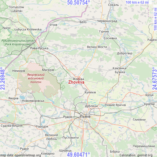
Zhovkva GPS coordinates[2]
50° 3' 29.7" North, 23° 58' 21.36" East
| Map corner | latitude | longitude |
|---|---|---|
| Upper-left | 50.50754°, | 23.26948° |
| Center: | 50.05825°, | 23.9726° |
| Lower-right: | 49.60471°, | 24.67573° |
| Map W x H: | 100.4×100.4 km | = 62.4×62.4mi |
| max Lat: | 52.18903° ⇑15.6% North |
| Zhovkva: | 50.05825° |
| min Lat: | ⇓84.4% South 44.39214° |
| min Long | Zhovkva | max Long |
| 22.20555° | 23.9726° | 40.13222° |
| W 7.4%⇐ | ⇒92.6% E |
Elevation
Elevation of Zhovkva is 232 m = 761 ft, and this is 76.2 m = 250 ft above average elevation for this country.
| Max E: |
886 m = 2907 ft | 23.4% |
| Zhovkva | 232 m 761 ft | |
| Avg. | 155.8 m = 511 ft | |
Min E: |
-3 m = -10 ft | 76.6% |
See also: Ukraine elevation on elevation.city.
Geographical zone
Zhovkva is located in North temperate zone (between Tropic of Cancer and the Arctic Circle). Distance of this North polar circle is 1835.2 km =1140.3 mi to North.| Distance of | km | miles | from Zhovkva |
|---|---|---|---|
| North Pole | 4441.1 | 2759.6 | to North |
| Arctic Circle | 1835.2 | 1140.3 | to North |
| Tropic Cancer | 2960 | 1839.3 | to South |
| Equator | 5566 | 3458.6 | to South |


Nearby cities:
15 places around Zhovkva: (largest is in red/bold)
• Bryukhovychi
17.1 km =10.6 mi,  183°
183°
• Dublyany
19 km =11.8 mi,  154°
154°
• Hlyns'k
5.2 km =3.2 mi,  272°
272°
• Ivano-Frankove
23.2 km =14.4 mi,  228°
228°
• Kamianka-Buzka
27.1 km =16.8 mi,  78°
78°
• Krekhiv
11.2 km =7 mi, 265°
• Kulykiv
11.6 km =7.2 mi,  139°
139°
• Lviv
24.7 km =15.3 mi,  171°
171°
• Novyi Yarychiv
29.3 km =18.2 mi,  125°
125°
• Rava-Rus’ka
31.1 km =19.3 mi,  308°
308°
• Rudne
25.5 km =15.8 mi,  191°
191°
• Silets’
31.3 km =19.4 mi,  31°
31°
• Starychi
30.8 km =19.1 mi,  253°
253°
• Sukhovolya
27.8 km =17.3 mi,  200°
200°
• Vereshitsa
25.6 km =15.9 mi, 252°
Sources, notices
• [Note1] Compared only with cities in Ukraine existing in our database
• [Src1] Map data: © OpenStreetMap contributors (CC-BY-SA)
• [Src2] Other city data from geonames.org with taken over terms of usage.
• [Src3] Geographical zone / Annual Mean Temperature by Robert A. Rohde @ Wikipedia
