Zybiny geodata
Zybiny (Republic of Crimea) is a seat of a third-order administrative division; located in Ukraine in Europe/Simferopol (GMT+3) time zone. With population of 1,220 people, there are 1289 cities with bigger population in this country. Compared to other cities in Ukraine, 84.9% of cities are located further ↑North; 75.6% of cities are located further ←West and 68% of cities have higher elevation than Zybiny. Note1
Administrative division(s):
- Level 1: Republic of Crimea
- Level 2: Belogorskiy rayon
- Level 3: Zybinskoye sel'skoye poselenye


Zybiny GPS coordinates[2]
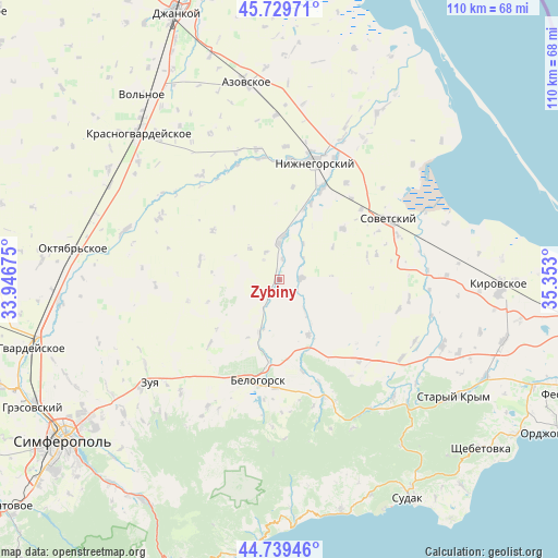
45° 14' 12.264" North, 34° 38' 59.532" East
| Map corner | latitude | longitude |
|---|---|---|
| Upper-left | 45.72971°, | 33.94675° |
| Center: | 45.23674°, | 34.64987° |
| Lower-right: | 44.73946°, | 35.353° |
| Map W x H: | 110.1×110.1 km | = 68.4×68.4mi |
| max Lat: | 52.18903° ⇑84.9% North |
| Zybiny: | 45.23674° |
| min Lat: | ⇓15.1% South 44.39214° |
| min Long | Zybiny | max Long |
| 22.20555° | 34.64987° | 40.13222° |
| W 75.6%⇐ | ⇒24.4% E |
Elevation
Elevation of Zybiny is 81 m = 266 ft, and this is 74.8 m = 245 ft below average elevation for this country.
| Max E: |
886 m = 2907 ft | 68% |
| Avg. | 155.8 m = 511 ft | |
| Zybiny | 81 m = 266 ft | |
Min E: |
-3 m = -10 ft | 32% |
See also: Ukraine elevation on elevation.city.
Geographical zone
Zybiny is located in North temperate zone (between Tropic of Cancer and the Arctic Circle). Distance of this North polar circle is 2371.3 km =1473.5 mi to North.| Distance of | km | miles | from Zybiny |
|---|---|---|---|
| North Pole | 4977.2 | 3092.7 | to North |
| Arctic Circle | 2371.3 | 1473.5 | to North |
| Tropic Cancer | 2423.9 | 1506.1 | to South |
| Equator | 5029.9 | 3125.4 | to South |


Nearby cities:
15 places around Zybiny: (largest is in red/bold)
• Belaya Skala
16.1 km =10 mi,  187°
187°
• Drofino
6.1 km =3.8 mi,  334°
334°
• Frunze
8.5 km =5.3 mi,  33°
33°
• Ivanovka
16.3 km =10.1 mi,  19°
19°
• Kostochkovka
9.2 km =5.7 mi,  11°
11°
• Naydenovka
16.2 km =10.1 mi,  283°
283°
• Pavlovka
8.3 km =5.2 mi,  141°
141°
• Pchel’niki
12.4 km =7.7 mi,  58°
58°
• Prudy
4.1 km =2.5 mi,  86°
86°
• Sadovoye
8.2 km =5.1 mi,  1°
1°
• Vasilyevka
12.2 km =7.6 mi,  152°
152°
• Vishennoye
11 km =6.8 mi,  202°
202°
• Zarech’ye
14.7 km =9.1 mi, 18°
• Zavetnoye
16 km =9.9 mi,  51°
51°
• Zhemchuzhina
4.3 km =2.7 mi, 8°
Sources, notices
• [Note1] Compared only with cities in Ukraine existing in our database
• [Src1] Map data: © OpenStreetMap contributors (CC-BY-SA)
• [Src2] Other city data from geonames.org with taken over terms of usage.
• [Src3] Geographical zone / Annual Mean Temperature by Robert A. Rohde @ Wikipedia
