Pavlovka geodata
Pavlovka (Republic of Crimea) is a populated place; located in Ukraine in Europe/Simferopol (GMT+3) time zone. With population of 590 people, there are 1594 cities with bigger population in this country. Compared to other cities in Ukraine, 86.3% of cities are located further ↑North; 76.5% of cities are located further ←West and 51.4% of cities have higher elevation than Pavlovka. Note1
Administrative division(s):
- Level 1: Republic of Crimea
- Level 2: Belogorskiy rayon
- Level 3: Vasilyevskoye sel'skoye poselenye


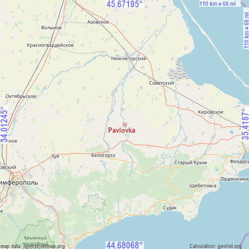
Pavlovka GPS coordinates[2]
45° 10' 42.492" North, 34° 42' 56.052" East
| Map corner | latitude | longitude |
|---|---|---|
| Upper-left | 45.67195°, | 34.01245° |
| Center: | 45.17847°, | 34.71557° |
| Lower-right: | 44.68068°, | 35.4187° |
| Map W x H: | 110.2×110.2 km | = 68.5×68.5mi |
| max Lat: | 52.18903° ⇑86.3% North |
| Pavlovka: | 45.17847° |
| min Lat: | ⇓13.7% South 44.39214° |
| min Long | Pavlovka | max Long |
| 22.20555° | 34.71557° | 40.13222° |
| W 76.5%⇐ | ⇒23.5% E |
Elevation
Elevation of Pavlovka is 129 m = 423 ft, and this is 26.8 m = 88 ft below average elevation for this country.
| Max E: |
886 m = 2907 ft | 51.4% |
| Avg. | 155.8 m = 511 ft | |
| Pavlovka | 129 m = 423 ft | |
Min E: |
-3 m = -10 ft | 48.6% |
See also: Ukraine elevation on elevation.city.
Geographical zone
Pavlovka is located in North temperate zone (between Tropic of Cancer and the Arctic Circle). Distance of this North polar circle is 2377.8 km =1477.5 mi to North.| Distance of | km | miles | from Pavlovka |
|---|---|---|---|
| North Pole | 4983.7 | 3096.7 | to North |
| Arctic Circle | 2377.8 | 1477.5 | to North |
| Tropic Cancer | 2417.5 | 1502.2 | to South |
| Equator | 5023.4 | 3121.4 | to South |


Nearby cities:
15 places around Pavlovka: (largest is in red/bold)
• Belaya Skala
12 km =7.5 mi,  217°
217°
• Chernopolye
16.1 km =10 mi,  201°
201°
• Drofino
14.3 km =8.9 mi,  326°
326°
• Frunze
13.5 km =8.4 mi,  358°
358°
• Kostochkovka
15.8 km =9.8 mi,  348°
348°
• Lechebnoye
14.3 km =8.9 mi,  169°
169°
• Michurinskoye
11.6 km =7.2 mi,  183°
183°
• Muromskoye
14.3 km =8.9 mi,  133°
133°
• Pchel’niki
14.1 km =8.8 mi,  22°
22°
• Prudy
6.8 km =4.2 mi, 351°
• Sadovoye
15.5 km =9.6 mi,  341°
341°
• Vasilyevka
4.4 km =2.7 mi, 172°
• Vishennoye
10 km =6.2 mi,  248°
248°
• Zhemchuzhina
11.6 km =7.2 mi, 337°
• Zybiny
8.3 km =5.2 mi,  321°
321°
Sources, notices
• [Note1] Compared only with cities in Ukraine existing in our database
• [Src1] Map data: © OpenStreetMap contributors (CC-BY-SA)
• [Src2] Other city data from geonames.org with taken over terms of usage.
• [Src3] Geographical zone / Annual Mean Temperature by Robert A. Rohde @ Wikipedia
