Vasilyevka geodata
Vasilyevka (Republic of Crimea) is a seat of a third-order administrative division; located in Ukraine in Europe/Simferopol (GMT+3) time zone. With population of 1,331 people, there are 1256 cities with bigger population in this country. Compared to other cities in Ukraine, 87.1% of cities are located further ↑North; 76.8% of cities are located further ←West and 60.1% of cities have lower elevation than Vasilyevka. Note1
Administrative division(s):
- Level 1: Republic of Crimea
- Level 2: Belogorskiy rayon
- Level 3: Vasilyevskoye sel'skoye poselenye


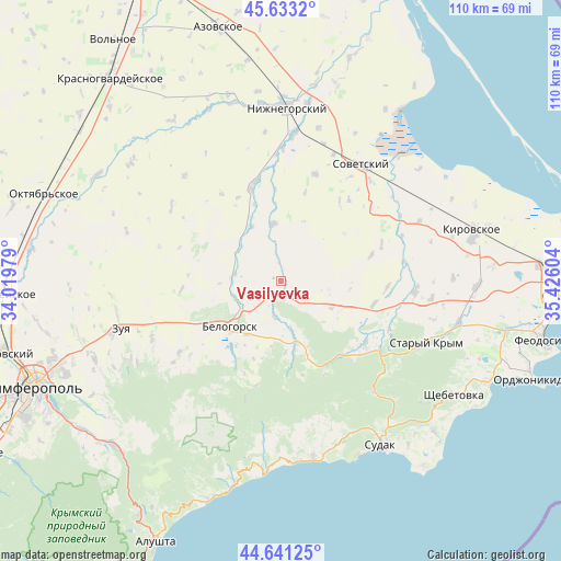
Vasilyevka GPS coordinates[2]
45° 8' 21.768" North, 34° 43' 22.476" East
| Map corner | latitude | longitude |
|---|---|---|
| Upper-left | 45.6332°, | 34.01979° |
| Center: | 45.13938°, | 34.72291° |
| Lower-right: | 44.64125°, | 35.42604° |
| Map W x H: | 110.3×110.3 km | = 68.5×68.5mi |
| max Lat: | 52.18903° ⇑87.1% North |
| Vasilyevka: | 45.13938° |
| min Lat: | ⇓12.9% South 44.39214° |
| min Long | Vasilyevka | max Long |
| 22.20555° | 34.72291° | 40.13222° |
| W 76.8%⇐ | ⇒23.2% E |
Elevation
Elevation of Vasilyevka is 169 m = 554 ft, and this is 13.2 m = 43 ft above average elevation for this country.
| Max E: |
886 m = 2907 ft | 39.9% |
| Vasilyevka | 169 m 554 ft | |
| Avg. | 155.8 m = 511 ft | |
Min E: |
-3 m = -10 ft | 60.1% |
See also: Ukraine elevation on elevation.city.
Geographical zone
Vasilyevka is located in North temperate zone (between Tropic of Cancer and the Arctic Circle). Distance of this North polar circle is 2382.1 km =1480.2 mi to North.| Distance of | km | miles | from Vasilyevka |
|---|---|---|---|
| North Pole | 4988 | 3099.4 | to North |
| Arctic Circle | 2382.1 | 1480.2 | to North |
| Tropic Cancer | 2413.1 | 1499.4 | to South |
| Equator | 5019 | 3118.7 | to South |


Nearby cities:
15 places around Vasilyevka: (largest is in red/bold)
• Belaya Skala
9.4 km =5.8 mi,  237°
237°
• Bilohirsk
13.4 km =8.3 mi,  225°
225°
• Bogatoye
12.7 km =7.9 mi,  164°
164°
• Chernopolye
12.5 km =7.8 mi,  211°
211°
• Frunze
17.9 km =11.1 mi,  356°
356°
• Krinichnoye
15.5 km =9.6 mi, 214°
• Lechebnoye
9.9 km =6.2 mi,  168°
168°
• Michurinskoye
7.3 km =4.5 mi,  189°
189°
• Muromskoye
11.3 km =7 mi,  118°
118°
• Pavlovka
4.4 km =2.7 mi,  352°
352°
• Pchel’niki
18 km =11.2 mi,  15°
15°
• Prudy
11.2 km =7 mi, 351°
• Vishennoye
9.9 km =6.2 mi,  273°
273°
• Zhemchuzhina
15.9 km =9.9 mi,  341°
341°
• Zybiny
12.2 km =7.6 mi,  332°
332°
Sources, notices
• [Note1] Compared only with cities in Ukraine existing in our database
• [Src1] Map data: © OpenStreetMap contributors (CC-BY-SA)
• [Src2] Other city data from geonames.org with taken over terms of usage.
• [Src3] Geographical zone / Annual Mean Temperature by Robert A. Rohde @ Wikipedia
