Bohodukhiv geodata
Bohodukhiv (Kharkiv) is a seat of a second-order administrative division; located in Ukraine in Europe/Kiev (GMT+3) time zone. With population of 17,818 people, there are 219 cities with bigger population in this country. Compared to other cities in Ukraine, 86.1% of cities are located further ↓South; 84.6% of cities are located further ←West and 54% of cities have lower elevation than Bohodukhiv. Note1


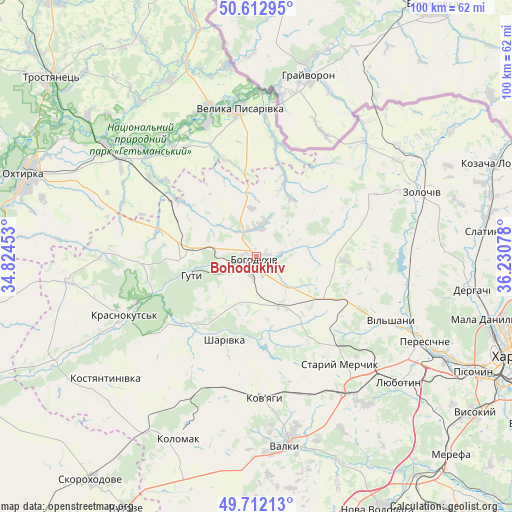
Bohodukhiv GPS coordinates[2]
50° 9' 52.776" North, 35° 31' 39.54" East
| Map corner | latitude | longitude |
|---|---|---|
| Upper-left | 50.61295°, | 34.82453° |
| Center: | 50.16466°, | 35.52765° |
| Lower-right: | 49.71213°, | 36.23078° |
| Map W x H: | 100.2×100.2 km | = 62.3×62.3mi |
| max Lat: | 52.18903° ⇑13.9% North |
| Bohodukhiv: | 50.16466° |
| min Lat: | ⇓86.1% South 44.39214° |
| min Long | Bohodukhiv | max Long |
| 22.20555° | 35.52765° | 40.13222° |
| W 84.6%⇐ | ⇒15.4% E |
Elevation
Elevation of Bohodukhiv is 150 m = 492 ft, and this is 5.8 m = 19 ft below average elevation for this country.
| Max E: |
886 m = 2907 ft | 46% |
| Avg. | 155.8 m = 511 ft | |
| Bohodukhiv | 150 m = 492 ft | |
Min E: |
-3 m = -10 ft | 54% |
See also: Ukraine elevation on elevation.city.
Geographical zone
Bohodukhiv is located in North temperate zone (between Tropic of Cancer and the Arctic Circle). Distance of this North polar circle is 1823.4 km =1133 mi to North.| Distance of | km | miles | from Bohodukhiv |
|---|---|---|---|
| North Pole | 4429.3 | 2752.2 | to North |
| Arctic Circle | 1823.4 | 1133 | to North |
| Tropic Cancer | 2971.9 | 1846.7 | to South |
| Equator | 5577.8 | 3465.9 | to South |


Nearby cities:
15 places around Bohodukhiv: (largest is in red/bold)
• Derhachi
42.8 km =26.6 mi,  98°
98°
• Huty
13.5 km =8.4 mi,  255°
255°
• Kolomak
39.5 km =24.5 mi,  203°
203°
• Korotych
43.7 km =27.2 mi,  123°
123°
• Krasnokuts’k
28.2 km =17.5 mi,  247°
247°
• Kyrykivka
36.8 km =22.9 mi,  307°
307°
• Lyubotyn
37.5 km =23.3 mi,  130°
130°
• Manchenky
31.3 km =19.4 mi, 131°
• Peresichna
35.7 km =22.2 mi, 115°
• Shlyakh
31.5 km =19.6 mi,  147°
147°
• Solonytsivka
40.7 km =25.3 mi, 117°
• Staryy Merchyk
26.2 km =16.3 mi,  140°
140°
• Valky
37 km =23 mi,  170°
170°
• Velyka Pysarivka
29.1 km =18.1 mi,  353°
353°
• Zolochiv
34.8 km =21.6 mi,  68°
68°
In other languages:
- In France: Bohodoukhiv
- In German: Bohoduchiw
- In Italian: Bohodochiv
- In Russian: Богодухів
- In Chinese: 博霍杜希夫
Sources, notices
• [Note1] Compared only with cities in Ukraine existing in our database
• [Src1] Map data: © OpenStreetMap contributors (CC-BY-SA)
• [Src2] Other city data from geonames.org with taken over terms of usage.
• [Src3] Geographical zone / Annual Mean Temperature by Robert A. Rohde @ Wikipedia
