Zaozyornoye geodata
Zaozyornoye (Republic of Crimea) is a populated place; located in Ukraine in Europe/Simferopol (GMT+3) time zone. With population of 4,332 people, there are 716 cities with bigger population in this country. Compared to other cities in Ukraine, 86.7% of cities are located further ↑North; 50.4% of cities are located further →East and 99.3% of cities have higher elevation than Zaozyornoye. Note1


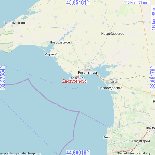
Zaozyornoye GPS coordinates[2]
45° 9' 29.376" North, 33° 16' 43.176" East
| Map corner | latitude | longitude |
|---|---|---|
| Upper-left | 45.65181°, | 32.57554° |
| Center: | 45.15816°, | 33.27866° |
| Lower-right: | 44.66019°, | 33.98179° |
| Map W x H: | 110.3×110.3 km | = 68.5×68.5mi |
| max Lat: | 52.18903° ⇑86.7% North |
| Zaozyornoye: | 45.15816° |
| min Lat: | ⇓13.3% South 44.39214° |
| min Long | Zaozyornoye | max Long |
| 22.20555° | 33.27866° | 40.13222° |
| W 49.6%⇐ | ⇒50.4% E |
Elevation
Elevation of Zaozyornoye is 4 m = 13 ft, and this is 151.8 m = 498 ft below average elevation for this country.
| Max E: |
886 m = 2907 ft | 99.3% |
| Avg. | 155.8 m = 511 ft | |
| Zaozyornoye | 4 m = 13 ft | |
Min E: |
-3 m = -10 ft | 0.7% |
See also: Ukraine elevation on elevation.city.
Geographical zone
Zaozyornoye is located in North temperate zone (between Tropic of Cancer and the Arctic Circle). Distance of this North polar circle is 2380.1 km =1478.9 mi to North.| Distance of | km | miles | from Zaozyornoye |
|---|---|---|---|
| North Pole | 4985.9 | 3098.1 | to North |
| Arctic Circle | 2380.1 | 1478.9 | to North |
| Tropic Cancer | 2415.2 | 1500.7 | to South |
| Equator | 5021.1 | 3120 | to South |


Nearby cities:
15 places around Zaozyornoye: (largest is in red/bold)
• Abrikosovka
14.3 km =8.9 mi,  331°
331°
• Kamenolomnya
14.8 km =9.2 mi,  47°
47°
• Koloski
12.4 km =7.7 mi,  5°
5°
• Kol’tsovo
23.2 km =14.4 mi,  35°
35°
• Molochnoye
6.4 km =4 mi,  316°
316°
• Pribrezhnoye
19 km =11.8 mi,  94°
94°
• Romashkino
11.1 km =6.9 mi,  350°
350°
• Shishkino
18 km =11.2 mi,  341°
341°
• Shtormovoye
19.3 km =12 mi,  308°
308°
• Suvorovskoye
12.7 km =7.9 mi, 35°
• Uyutnoye
4.6 km =2.9 mi,  18°
18°
• Vitino
11.4 km =7.1 mi,  304°
304°
• Vladimirovka
23.3 km =14.5 mi, 92°
• Vorobyovo
19.2 km =11.9 mi, 352°
• Yevpatoriya
8.4 km =5.2 mi,  55°
55°
Sources, notices
• [Note1] Compared only with cities in Ukraine existing in our database
• [Src1] Map data: © OpenStreetMap contributors (CC-BY-SA)
• [Src2] Other city data from geonames.org with taken over terms of usage.
• [Src3] Geographical zone / Annual Mean Temperature by Robert A. Rohde @ Wikipedia
