Suvorovskoye geodata
Suvorovskoye (Republic of Crimea) is a seat of a third-order administrative division; located in Ukraine in Europe/Simferopol (GMT+3) time zone. With population of 3,200 people, there are 886 cities with bigger population in this country. Compared to other cities in Ukraine, 84.2% of cities are located further ↑North; 50.5% of cities are located further ←West and 93% of cities have higher elevation than Suvorovskoye. Note1
Administrative division(s):
- Level 1: Republic of Crimea
- Level 2: Sakskiy rayon
- Level 3: Suvorovskoye sel'skoye poselenye


Suvorovskoye GPS coordinates[2]
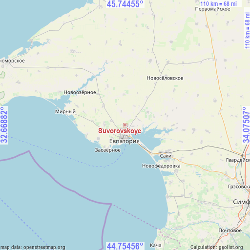
45° 15' 6.156" North, 33° 22' 18.984" East
| Map corner | latitude | longitude |
|---|---|---|
| Upper-left | 45.74455°, | 32.66882° |
| Center: | 45.25171°, | 33.37194° |
| Lower-right: | 44.75456°, | 34.07507° |
| Map W x H: | 110.1×110.1 km | = 68.4×68.4mi |
| max Lat: | 52.18903° ⇑84.2% North |
| Suvorovskoye: | 45.25171° |
| min Lat: | ⇓15.8% South 44.39214° |
| min Long | Suvorovskoye | max Long |
| 22.20555° | 33.37194° | 40.13222° |
| W 50.5%⇐ | ⇒49.5% E |
Elevation
Elevation of Suvorovskoye is 15 m = 49 ft, and this is 140.8 m = 462 ft below average elevation for this country.
| Max E: |
886 m = 2907 ft | 93% |
| Avg. | 155.8 m = 511 ft | |
| Suvorovskoye | 15 m = 49 ft | |
Min E: |
-3 m = -10 ft | 7% |
See also: Ukraine elevation on elevation.city.
Geographical zone
Suvorovskoye is located in North temperate zone (between Tropic of Cancer and the Arctic Circle). Distance of this North polar circle is 2369.7 km =1472.5 mi to North.| Distance of | km | miles | from Suvorovskoye |
|---|---|---|---|
| North Pole | 4975.5 | 3091.6 | to North |
| Arctic Circle | 2369.7 | 1472.5 | to North |
| Tropic Cancer | 2425.6 | 1507.2 | to South |
| Equator | 5031.5 | 3126.4 | to South |


Nearby cities:
15 places around Suvorovskoye: (largest is in red/bold)
• Abrikosovka
14.3 km =8.9 mi,  278°
278°
• Dobrushino
13.7 km =8.5 mi,  357°
357°
• Glinka
13.2 km =8.2 mi,  73°
73°
• Kamenolomnya
3.6 km =2.2 mi,  96°
96°
• Koloski
6.4 km =4 mi,  287°
287°
• Kol’tsovo
10.5 km =6.5 mi,  35°
35°
• Molochnoye
13.1 km =8.1 mi,  243°
243°
• Orlyanka
15.2 km =9.4 mi, 96°
• Romashkino
9.2 km =5.7 mi,  273°
273°
• Shishkino
14.6 km =9.1 mi,  297°
297°
• Uyutnoye
8.3 km =5.2 mi,  223°
223°
• Veresayevo
11.7 km =7.3 mi,  59°
59°
• Vorobyovo
13 km =8.1 mi,  311°
311°
• Yevpatoriya
5.7 km =3.5 mi,  184°
184°
• Zaozyornoye
12.7 km =7.9 mi, 215°
Sources, notices
• [Note1] Compared only with cities in Ukraine existing in our database
• [Src1] Map data: © OpenStreetMap contributors (CC-BY-SA)
• [Src2] Other city data from geonames.org with taken over terms of usage.
• [Src3] Geographical zone / Annual Mean Temperature by Robert A. Rohde @ Wikipedia
