Romashkino geodata
Romashkino (Republic of Crimea) is a seat of a third-order administrative division; located in Ukraine in Europe/Simferopol (GMT+3) time zone. With population of 1,427 people, there are 1230 cities with bigger population in this country. Compared to other cities in Ukraine, 84.1% of cities are located further ↑North; 51% of cities are located further →East and 81.7% of cities have higher elevation than Romashkino. Note1
Administrative division(s):
- Level 1: Republic of Crimea
- Level 2: Sakskiy rayon
- Level 3: Romashkinskoye sel'skoye poselenye


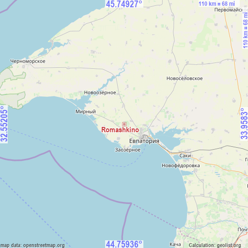
Romashkino GPS coordinates[2]
45° 15' 23.292" North, 33° 15' 18.612" East
| Map corner | latitude | longitude |
|---|---|---|
| Upper-left | 45.74927°, | 32.55205° |
| Center: | 45.25647°, | 33.25517° |
| Lower-right: | 44.75936°, | 33.9583° |
| Map W x H: | 110.1×110.1 km | = 68.4×68.4mi |
| max Lat: | 52.18903° ⇑84.1% North |
| Romashkino: | 45.25647° |
| min Lat: | ⇓15.9% South 44.39214° |
| min Long | Romashkino | max Long |
| 22.20555° | 33.25517° | 40.13222° |
| W 49%⇐ | ⇒51% E |
Elevation
Elevation of Romashkino is 38 m = 125 ft, and this is 117.8 m = 386 ft below average elevation for this country.
| Max E: |
886 m = 2907 ft | 81.7% |
| Avg. | 155.8 m = 511 ft | |
| Romashkino | 38 m = 125 ft | |
Min E: |
-3 m = -10 ft | 18.3% |
See also: Ukraine elevation on elevation.city.
Geographical zone
Romashkino is located in North temperate zone (between Tropic of Cancer and the Arctic Circle). Distance of this North polar circle is 2369.1 km =1472.1 mi to North.| Distance of | km | miles | from Romashkino |
|---|---|---|---|
| North Pole | 4975 | 3091.3 | to North |
| Arctic Circle | 2369.1 | 1472.1 | to North |
| Tropic Cancer | 2426.1 | 1507.5 | to South |
| Equator | 5032 | 3126.7 | to South |


Nearby cities:
15 places around Romashkino: (largest is in red/bold)
• Abrikosovka
5.2 km =3.2 mi,  287°
287°
• Dobrushino
15.7 km =9.8 mi,  33°
33°
• Kamenolomnya
12.8 km =8 mi,  94°
94°
• Koloski
3.4 km =2.1 mi,  64°
64°
• Molochnoye
6.8 km =4.2 mi,  202°
202°
• Natashino
16.9 km =10.5 mi,  4°
4°
• Shishkino
7.3 km =4.5 mi,  327°
327°
• Shtormovoye
13.2 km =8.2 mi,  275°
275°
• Suvorovskoye
9.2 km =5.7 mi, 93°
• Uyutnoye
7.3 km =4.5 mi,  152°
152°
• Veselovka
13.8 km =8.6 mi,  346°
346°
• Vitino
8.7 km =5.4 mi,  239°
239°
• Vorobyovo
8.1 km =5 mi,  355°
355°
• Yevpatoriya
10.7 km =6.6 mi,  125°
125°
• Zaozyornoye
11.1 km =6.9 mi,  170°
170°
Sources, notices
• [Note1] Compared only with cities in Ukraine existing in our database
• [Src1] Map data: © OpenStreetMap contributors (CC-BY-SA)
• [Src2] Other city data from geonames.org with taken over terms of usage.
• [Src3] Geographical zone / Annual Mean Temperature by Robert A. Rohde @ Wikipedia
