Koloski geodata
Koloski (Republic of Crimea) is a populated place; located in Ukraine in Europe/Simferopol (GMT+3) time zone. With population of 1,116 people, there are 1329 cities with bigger population in this country. Compared to other cities in Ukraine, 83.8% of cities are located further ↑North; 50.2% of cities are located further →East and 81.7% of cities have higher elevation than Koloski. Note1
Administrative division(s):
- Level 1: Republic of Crimea
- Level 2: Sakskiy rayon
- Level 3: Romashkinskoye sel'skoye poselenye


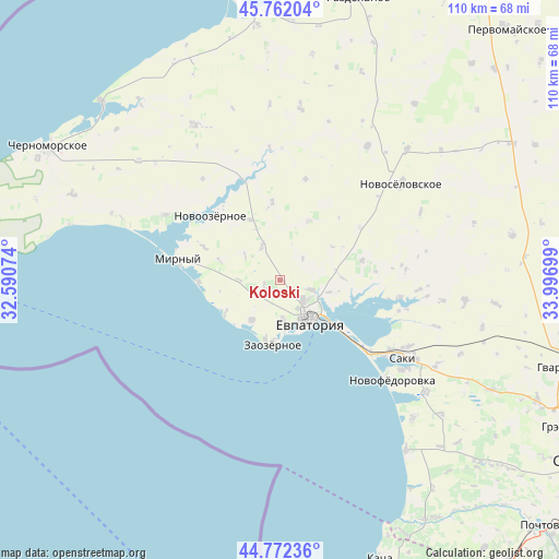
Koloski GPS coordinates[2]
45° 16' 9.696" North, 33° 17' 37.896" East
| Map corner | latitude | longitude |
|---|---|---|
| Upper-left | 45.76204°, | 32.59074° |
| Center: | 45.26936°, | 33.29386° |
| Lower-right: | 44.77236°, | 33.99699° |
| Map W x H: | 110×110 km | = 68.4×68.4mi |
| max Lat: | 52.18903° ⇑83.8% North |
| Koloski: | 45.26936° |
| min Lat: | ⇓16.2% South 44.39214° |
| min Long | Koloski | max Long |
| 22.20555° | 33.29386° | 40.13222° |
| W 49.8%⇐ | ⇒50.2% E |
Elevation
Elevation of Koloski is 38 m = 125 ft, and this is 117.8 m = 386 ft below average elevation for this country.
| Max E: |
886 m = 2907 ft | 81.7% |
| Avg. | 155.8 m = 511 ft | |
| Koloski | 38 m = 125 ft | |
Min E: |
-3 m = -10 ft | 18.3% |
See also: Ukraine elevation on elevation.city.
Geographical zone
Koloski is located in North temperate zone (between Tropic of Cancer and the Arctic Circle). Distance of this North polar circle is 2367.7 km =1471.2 mi to North.| Distance of | km | miles | from Koloski |
|---|---|---|---|
| North Pole | 4973.6 | 3090.5 | to North |
| Arctic Circle | 2367.7 | 1471.2 | to North |
| Tropic Cancer | 2427.6 | 1508.4 | to South |
| Equator | 5033.5 | 3127.7 | to South |


Nearby cities:
15 places around Koloski: (largest is in red/bold)
• Abrikosovka
8 km =5 mi,  270°
270°
• Dobrushino
13 km =8.1 mi,  25°
25°
• Kamenolomnya
10 km =6.2 mi,  103°
103°
• Kol’tsovo
13.8 km =8.6 mi,  61°
61°
• Molochnoye
9.6 km =6 mi,  215°
215°
• Natashino
15.5 km =9.6 mi,  354°
354°
• Romashkino
3.4 km =2.1 mi,  244°
244°
• Shishkino
8.4 km =5.2 mi,  304°
304°
• Suvorovskoye
6.4 km =4 mi,  107°
107°
• Uyutnoye
8 km =5 mi,  177°
177°
• Veselovka
13.5 km =8.4 mi,  332°
332°
• Vitino
12 km =7.5 mi, 240°
• Vorobyovo
7.6 km =4.7 mi, 330°
• Yevpatoriya
9.5 km =5.9 mi,  143°
143°
• Zaozyornoye
12.4 km =7.7 mi,  185°
185°
Sources, notices
• [Note1] Compared only with cities in Ukraine existing in our database
• [Src1] Map data: © OpenStreetMap contributors (CC-BY-SA)
• [Src2] Other city data from geonames.org with taken over terms of usage.
• [Src3] Geographical zone / Annual Mean Temperature by Robert A. Rohde @ Wikipedia
