Zakupne geodata
Zakupne (Khmelnytskyi) is a populated place; located in Ukraine in Europe/Kiev (GMT+3) time zone. With population of 1,398 people, there are 1239 cities with bigger population in this country. Compared to other cities in Ukraine, 68.8% of cities are located further ↓South; 79.7% of cities are located further →East and 92.2% of cities have lower elevation than Zakupne. Note1


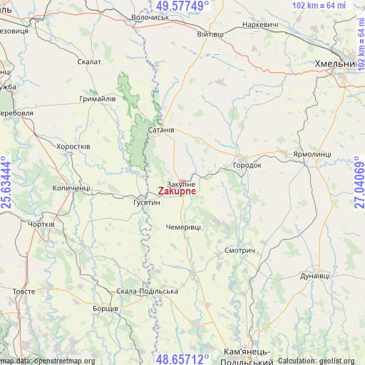
Zakupne GPS coordinates[2]
49° 7' 9.984" North, 26° 20' 15.216" East
| Map corner | latitude | longitude |
|---|---|---|
| Upper-left | 49.57749°, | 25.63444° |
| Center: | 49.11944°, | 26.33756° |
| Lower-right: | 48.65712°, | 27.04069° |
| Map W x H: | 102.3×102.3 km | = 63.6×63.6mi |
| max Lat: | 52.18903° ⇑31.2% North |
| Zakupne: | 49.11944° |
| min Lat: | ⇓68.8% South 44.39214° |
| min Long | Zakupne | max Long |
| 22.20555° | 26.33756° | 40.13222° |
| W 20.3%⇐ | ⇒79.7% E |
Elevation
Elevation of Zakupne is 322 m = 1056 ft, and this is 166.2 m = 545 ft above average elevation for this country.
| Max E: |
886 m = 2907 ft | 7.8% |
| Zakupne | 322 m 1056 ft | |
| Avg. | 155.8 m = 511 ft | |
Min E: |
-3 m = -10 ft | 92.2% |
See also: Ukraine elevation on elevation.city.
Geographical zone
Zakupne is located in North temperate zone (between Tropic of Cancer and the Arctic Circle). Distance of this North polar circle is 1939.6 km =1205.2 mi to North.| Distance of | km | miles | from Zakupne |
|---|---|---|---|
| North Pole | 4545.5 | 2824.4 | to North |
| Arctic Circle | 1939.6 | 1205.2 | to North |
| Tropic Cancer | 2855.7 | 1774.4 | to South |
| Equator | 5461.6 | 3393.7 | to South |


Nearby cities:
15 places around Zakupne: (largest is in red/bold)
• Belaya
42.5 km =26.4 mi,  256°
256°
• Borshchiv
41.2 km =25.6 mi,  211°
211°
• Chemerivtsi
12 km =7.5 mi,  178°
178°
• Chortkiv
40.9 km =25.4 mi,  253°
253°
• Dunayivtsi
38.3 km =23.8 mi,  106°
106°
• Horodok
18.6 km =11.6 mi,  74°
74°
• Hrymayliv
33.5 km =20.8 mi,  314°
314°
• Husiatyn
10 km =6.2 mi,  236°
236°
• Husiatyn
12.3 km =7.6 mi, 245°
• Khorostkiv
31.9 km =19.8 mi,  288°
288°
• Kopychyntsi
31.1 km =19.3 mi,  266°
266°
• Novoye Sëlo
34.1 km =21.2 mi,  79°
79°
• Skala-Podil’s’ka
31.5 km =19.6 mi,  198°
198°
• Skalat
43 km =26.7 mi,  322°
322°
• Yarmolyntsi
37.2 km =23.1 mi, 77°
Sources, notices
• [Note1] Compared only with cities in Ukraine existing in our database
• [Src1] Map data: © OpenStreetMap contributors (CC-BY-SA)
• [Src2] Other city data from geonames.org with taken over terms of usage.
• [Src3] Geographical zone / Annual Mean Temperature by Robert A. Rohde @ Wikipedia
