Borshchiv geodata
Borshchiv (Ternopil) is a seat of a second-order administrative division; located in Ukraine in Europe/Kiev (GMT+3) time zone. With population of 10,959 people, there are 332 cities with bigger population in this country. Compared to other cities in Ukraine, 62% of cities are located further ↓South; 80.9% of cities are located further →East and 81.2% of cities have lower elevation than Borshchiv. Note1


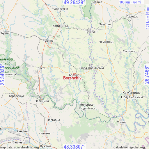
Borshchiv GPS coordinates[2]
48° 48' 11.952" North, 26° 2' 36.492" East
| Map corner | latitude | longitude |
|---|---|---|
| Upper-left | 49.26429°, | 25.34035° |
| Center: | 48.80332°, | 26.04347° |
| Lower-right: | 48.33807°, | 26.7466° |
| Map W x H: | 103×103 km | = 64×64mi |
| max Lat: | 52.18903° ⇑38% North |
| Borshchiv: | 48.80332° |
| min Lat: | ⇓62% South 44.39214° |
| min Long | Borshchiv | max Long |
| 22.20555° | 26.04347° | 40.13222° |
| W 19.1%⇐ | ⇒80.9% E |
Elevation
Elevation of Borshchiv is 253 m = 830 ft, and this is 97.2 m = 319 ft above average elevation for this country.
| Max E: |
886 m = 2907 ft | 18.8% |
| Borshchiv | 253 m 830 ft | |
| Avg. | 155.8 m = 511 ft | |
Min E: |
-3 m = -10 ft | 81.2% |
See also: Ukraine elevation on elevation.city.
Geographical zone
Borshchiv is located in North temperate zone (between Tropic of Cancer and the Arctic Circle). Distance of this North polar circle is 1974.8 km =1227.1 mi to North.| Distance of | km | miles | from Borshchiv |
|---|---|---|---|
| North Pole | 4580.6 | 2846.3 | to North |
| Arctic Circle | 1974.8 | 1227.1 | to North |
| Tropic Cancer | 2820.5 | 1752.6 | to South |
| Equator | 5426.4 | 3371.8 | to South |


Nearby cities:
15 places around Borshchiv: (largest is in red/bold)
• Belaya
32.1 km =19.9 mi,  321°
321°
• Chemerivtsi
31.8 km =19.8 mi,  43°
43°
• Chortkiv
29.8 km =18.5 mi, 322°
• Husiatyn
31.7 km =19.7 mi,  19°
19°
• Husiatyn
32.4 km =20.1 mi, 23°
• Kadubivtsi
31.7 km =19.7 mi,  219°
219°
• Kopychyntsi
34.9 km =21.7 mi,  343°
343°
• Kostryzhivka
29.3 km =18.2 mi,  235°
235°
• Nyrkiv
32.5 km =20.2 mi,  272°
272°
• Skala-Podil’s’ka
12.6 km =7.8 mi,  64°
64°
• Tovste
23.7 km =14.7 mi,  281°
281°
• Yagel’nitsa Stara
31.2 km =19.4 mi,  308°
308°
• Yahil’nytsya
26.8 km =16.7 mi, 305°
• Zalishchyky
28.6 km =17.8 mi,  231°
231°
• Zastavna
34.4 km =21.4 mi,  205°
205°
Sources, notices
• [Note1] Compared only with cities in Ukraine existing in our database
• [Src1] Map data: © OpenStreetMap contributors (CC-BY-SA)
• [Src2] Other city data from geonames.org with taken over terms of usage.
• [Src3] Geographical zone / Annual Mean Temperature by Robert A. Rohde @ Wikipedia
