Dunayivtsi geodata
Dunayivtsi (Khmelnytskyi) is a seat of a second-order administrative division; located in Ukraine in Europe/Kiev (GMT+3) time zone. In our database, there are 1661 cities with bigger population. Compared to other cities in Ukraine, 66.9% of cities are located further ↓South; 78.3% of cities are located further →East and 88.1% of cities have lower elevation than Dunayivtsi. Note1


Dunayivtsi GPS coordinates[2]
49° 1' 14.808" North, 26° 50' 28.392" East
| Map corner | latitude | longitude |
|---|---|---|
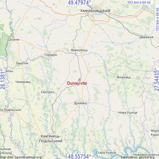
| Upper-left | 49.47974°, | 26.1381° |
| Center: | 49.02078°, | 26.84122° |
| Lower-right: | 48.55754°, | 27.54435° |
| Map W x H: | 102.5×102.5 km | = 63.7×63.7mi |
| max Lat: | 52.18903° ⇑33.1% North |
| Dunayivtsi: | 49.02078° |
| min Lat: | ⇓66.9% South 44.39214° |
| min Long | Dunayivtsi | max Long |
| 22.20555° | 26.84122° | 40.13222° |
| W 21.7%⇐ | ⇒78.3% E |
Elevation
Elevation of Dunayivtsi is 295 m = 968 ft, and this is 139.2 m = 457 ft above average elevation for this country.
| Max E: |
886 m = 2907 ft | 11.9% |
| Dunayivtsi | 295 m 968 ft | |
| Avg. | 155.8 m = 511 ft | |
Min E: |
-3 m = -10 ft | 88.1% |
See also: Ukraine elevation on elevation.city.
Geographical zone
Dunayivtsi is located in North temperate zone (between Tropic of Cancer and the Arctic Circle). Distance of this North polar circle is 1950.6 km =1212 mi to North.| Distance of | km | miles | from Dunayivtsi |
|---|---|---|---|
| North Pole | 4556.5 | 2831.3 | to North |
| Arctic Circle | 1950.6 | 1212 | to North |
| Tropic Cancer | 2844.7 | 1767.6 | to South |
| Equator | 5450.6 | 3386.8 | to South |


Nearby cities:
15 places around Dunayivtsi: (largest is in red/bold)
• Chemerivtsi
36.4 km =22.6 mi,  268°
268°
• Dunaivtsi
14.7 km =9.1 mi,  175°
175°
• Horodok
24.6 km =15.3 mi,  310°
310°
• Husiatyn
45.4 km =28.2 mi,  276°
276°
• Husiatyn
48.2 km =30 mi, 276°
• Kamianets-Podilskyi
41.8 km =26 mi,  206°
206°
• Khmelnytskyi
46 km =28.6 mi,  14°
14°
• Makiv
27.4 km =17 mi,  203°
203°
• Nova Ushytsya
37.7 km =23.4 mi,  122°
122°
• Novoye Sëlo
17.4 km =10.8 mi,  349°
349°
• Skala-Podil’s’ka
50.5 km =31.4 mi,  248°
248°
• Smotrych
44.9 km =27.9 mi, 207°
• Vinkivtsi
28.8 km =17.9 mi,  86°
86°
• Yarmolyntsi
19.1 km =11.9 mi,  359°
359°
• Zakupne
38.3 km =23.8 mi,  286°
286°
Sources, notices
• [Note1] Compared only with cities in Ukraine existing in our database
• [Src1] Map data: © OpenStreetMap contributors (CC-BY-SA)
• [Src2] Other city data from geonames.org with taken over terms of usage.
• [Src3] Geographical zone / Annual Mean Temperature by Robert A. Rohde @ Wikipedia
