Skala-Podil’s’ka geodata
Skala-Podil’s’ka (Ternopil) is a populated place; located in Ukraine in Europe/Kiev (GMT+3) time zone. With population of 4,255 people, there are 729 cities with bigger population in this country. Compared to other cities in Ukraine, 63% of cities are located further ↓South; 80.3% of cities are located further →East and 79.9% of cities have lower elevation than Skala-Podil’s’ka. Note1


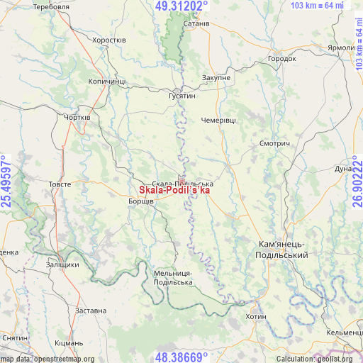
Skala-Podil’s’ka GPS coordinates[2]
48° 51' 5.364" North, 26° 11' 56.724" East
| Map corner | latitude | longitude |
|---|---|---|
| Upper-left | 49.31202°, | 25.49597° |
| Center: | 48.85149°, | 26.19909° |
| Lower-right: | 48.38669°, | 26.90222° |
| Map W x H: | 102.9×102.9 km | = 63.9×63.9mi |
| max Lat: | 52.18903° ⇑37% North |
| Skala-Podil’s’ka: | 48.85149° |
| min Lat: | ⇓63% South 44.39214° |
| min Long | Skala-Podil’s | max Long |
| 22.20555° | 26.19909° | 40.13222° |
| W 19.7%⇐ | ⇒80.3% E |
Elevation
Elevation of Skala-Podil’s’ka is 246 m = 807 ft, and this is 90.2 m = 296 ft above average elevation for this country.
| Max E: |
886 m = 2907 ft | 20.1% |
| Skala-Podil’s’ka | 246 m 807 ft | |
| Avg. | 155.8 m = 511 ft | |
Min E: |
-3 m = -10 ft | 79.9% |
See also: Ukraine elevation on elevation.city.
Geographical zone
Skala-Podil’s’ka is located in North temperate zone (between Tropic of Cancer and the Arctic Circle). Distance of this North polar circle is 1969.4 km =1223.7 mi to North.| Distance of | km | miles | from Skala-Podil’s’ka |
|---|---|---|---|
| North Pole | 4575.3 | 2843 | to North |
| Arctic Circle | 1969.4 | 1223.7 | to North |
| Tropic Cancer | 2825.9 | 1755.9 | to South |
| Equator | 5431.8 | 3375.2 | to South |


Nearby cities:
15 places around Skala-Podil’s’ka: (largest is in red/bold)
• Belaya
37 km =23 mi,  302°
302°
• Borshchiv
12.6 km =7.8 mi,  244°
244°
• Chemerivtsi
20.7 km =12.9 mi,  30°
30°
• Chortkiv
34.6 km =21.5 mi, 302°
• Husiatyn
24.4 km =15.2 mi,  4°
4°
• Husiatyn
24.6 km =15.3 mi,  357°
357°
• Kamianets-Podilskyi
33.9 km =21.1 mi,  123°
123°
• Kopychyntsi
35.1 km =21.8 mi,  323°
323°
• Makiv
36.6 km =22.7 mi,  99°
99°
• Smotrych
33.9 km =21.1 mi,  128°
128°
• Tovste
34.6 km =21.5 mi,  269°
269°
• Yagel’nitsa Stara
38.4 km =23.9 mi,  291°
291°
• Yahil’nytsya
34.8 km =21.6 mi, 286°
• Zakupne
31.5 km =19.6 mi,  18°
18°
• Zhvanets
39.7 km =24.7 mi,  147°
147°
Sources, notices
• [Note1] Compared only with cities in Ukraine existing in our database
• [Src1] Map data: © OpenStreetMap contributors (CC-BY-SA)
• [Src2] Other city data from geonames.org with taken over terms of usage.
• [Src3] Geographical zone / Annual Mean Temperature by Robert A. Rohde @ Wikipedia
