Luhans’ke geodata
Luhans’ke (Donetsk) is a populated place; located in Ukraine in Europe/Kiev (GMT+3) time zone. With population of 2,604 people, there are 1014 cities with bigger population in this country. Compared to other cities in Ukraine, 53.9% of cities are located further ↓South; 95.9% of cities are located further ←West and 56.3% of cities have lower elevation than Luhans’ke. Note1


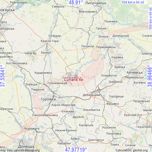
Luhans’ke GPS coordinates[2]
48° 26' 44.664" North, 38° 15' 41.508" East
| Map corner | latitude | longitude |
|---|---|---|
| Upper-left | 48.91°, | 37.55841° |
| Center: | 48.44574°, | 38.26153° |
| Lower-right: | 47.97719°, | 38.96466° |
| Map W x H: | 103.7×103.7 km | = 64.4×64.4mi |
| max Lat: | 52.18903° ⇑46.1% North |
| Luhans’ke: | 48.44574° |
| min Lat: | ⇓53.9% South 44.39214° |
| min Long | Luhans’ke | max Long |
| 22.20555° | 38.26153° | 40.13222° |
| W 95.9%⇐ | ⇒4.1% E |
Elevation
Elevation of Luhans’ke is 156 m = 512 ft, and this is 0.19999999999999 m = 1 ft above average elevation for this country.
| Max E: |
886 m = 2907 ft | 43.7% |
| Luhans’ke | 156 m 512 ft | |
| Avg. | 155.8 m = 511 ft | |
Min E: |
-3 m = -10 ft | 56.3% |
See also: Ukraine elevation on elevation.city.
Geographical zone
Luhans’ke is located in North temperate zone (between Tropic of Cancer and the Arctic Circle). Distance of this North polar circle is 2014.5 km =1251.8 mi to North.| Distance of | km | miles | from Luhans’ke |
|---|---|---|---|
| North Pole | 4620.4 | 2871 | to North |
| Arctic Circle | 2014.5 | 1251.8 | to North |
| Tropic Cancer | 2780.7 | 1727.8 | to South |
| Equator | 5386.7 | 3347.1 | to South |


Nearby cities:
15 places around Luhans’ke: (largest is in red/bold)
• Bakhmut
25.5 km =15.8 mi,  310°
310°
• Bayrachky
25.8 km =16 mi,  103°
103°
• Bryanka
31.1 km =19.3 mi,  76°
76°
• Chornukhyne
23.6 km =14.7 mi,  125°
125°
• Debal’tseve
15.8 km =9.8 mi,  137°
137°
• Horlivka
19.6 km =12.2 mi,  231°
231°
• Krasnyy Oktyabr’
22.2 km =13.8 mi,  191°
191°
• Pervomays’k
29.4 km =18.3 mi,  45°
45°
• Popasna
22.5 km =14 mi,  22°
22°
• Soledar
28.9 km =18 mi,  333°
333°
• Svetlodarsk
3.1 km =1.9 mi,  244°
244°
• Toretsk
31 km =19.3 mi,  260°
260°
• Vuhlehirs’k
14.6 km =9.1 mi,  176°
176°
• Yenakiyeve
23.9 km =14.9 mi, 188°
• Zoryns’k
27 km =16.8 mi, 98°
Sources, notices
• [Note1] Compared only with cities in Ukraine existing in our database
• [Src1] Map data: © OpenStreetMap contributors (CC-BY-SA)
• [Src2] Other city data from geonames.org with taken over terms of usage.
• [Src3] Geographical zone / Annual Mean Temperature by Robert A. Rohde @ Wikipedia
