Chornukhyne geodata
Chornukhyne (Luhansk) is a populated place; located in Ukraine in Europe/Zaporozhye (GMT+3) time zone. With population of 7,782 people, there are 459 cities with bigger population in this country. Compared to other cities in Ukraine, 50.5% of cities are located further ↓South; 96.8% of cities are located further ←West and 90.5% of cities have lower elevation than Chornukhyne. Note1


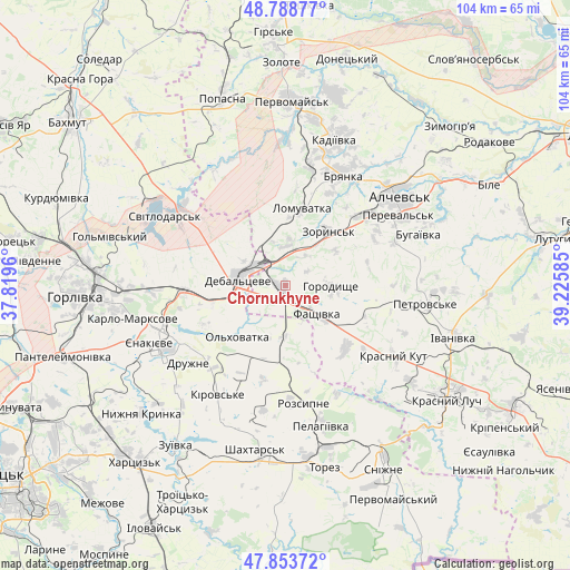
Chornukhyne GPS coordinates[2]
48° 19' 24.204" North, 38° 31' 21.792" East
| Map corner | latitude | longitude |
|---|---|---|
| Upper-left | 48.78877°, | 37.8196° |
| Center: | 48.32339°, | 38.52272° |
| Lower-right: | 47.85372°, | 39.22585° |
| Map W x H: | 104×104 km | = 64.6×64.6mi |
| max Lat: | 52.18903° ⇑49.5% North |
| Chornukhyne: | 48.32339° |
| min Lat: | ⇓50.5% South 44.39214° |
| min Long | Chornukhyne | max Long |
| 22.20555° | 38.52272° | 40.13222° |
| W 96.8%⇐ | ⇒3.2% E |
Elevation
Elevation of Chornukhyne is 311 m = 1020 ft, and this is 155.2 m = 509 ft above average elevation for this country.
| Max E: |
886 m = 2907 ft | 9.5% |
| Chornukhyne | 311 m 1020 ft | |
| Avg. | 155.8 m = 511 ft | |
Min E: |
-3 m = -10 ft | 90.5% |
See also: Ukraine elevation on elevation.city.
Geographical zone
Chornukhyne is located in North temperate zone (between Tropic of Cancer and the Arctic Circle). Distance of this North polar circle is 2028.1 km =1260.2 mi to North.| Distance of | km | miles | from Chornukhyne |
|---|---|---|---|
| North Pole | 4634 | 2879.4 | to North |
| Arctic Circle | 2028.1 | 1260.2 | to North |
| Tropic Cancer | 2767.1 | 1719.4 | to South |
| Equator | 5373.1 | 3338.7 | to South |


Nearby cities:
15 places around Chornukhyne: (largest is in red/bold)
• Alchevs’k
27.1 km =16.8 mi,  53°
53°
• Artemivs’k
20.2 km =12.6 mi, 49°
• Bayrachky
9.6 km =6 mi,  37°
37°
• Bryanka
23.6 km =14.7 mi,  27°
27°
• Debal’tseve
8.9 km =5.5 mi,  282°
282°
• Krasnyy Kut
24.5 km =15.2 mi,  123°
123°
• Krasnyy Oktyabr’
25.2 km =15.7 mi,  251°
251°
• Luhans’ke
23.6 km =14.7 mi,  305°
305°
• Pereval’s’k
26.9 km =16.7 mi,  61°
61°
• Rozsypne
19.7 km =12.2 mi,  168°
168°
• Stizhkivs’ke
23.5 km =14.6 mi,  185°
185°
• Svetlodarsk
25.3 km =15.7 mi,  299°
299°
• Vuhlehirs’k
18.4 km =11.4 mi,  267°
267°
• Yenakiyeve
25.1 km =15.6 mi, 246°
• Zoryns’k
12.3 km =7.6 mi, 37°
Sources, notices
• [Note1] Compared only with cities in Ukraine existing in our database
• [Src1] Map data: © OpenStreetMap contributors (CC-BY-SA)
• [Src2] Other city data from geonames.org with taken over terms of usage.
• [Src3] Geographical zone / Annual Mean Temperature by Robert A. Rohde @ Wikipedia
