Yavoriv geodata
Yavoriv (Lviv) is a seat of a second-order administrative division; located in Ukraine in Europe/Kiev (GMT+3) time zone. With population of 13,008 people, there are 284 cities with bigger population in this country. Compared to other cities in Ukraine, 82.4% of cities are located further ↓South; 96.6% of cities are located further →East and 76.3% of cities have lower elevation than Yavoriv. Note1


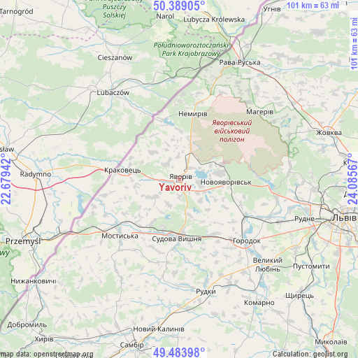
Yavoriv GPS coordinates[2]
49° 56' 19.104" North, 23° 22' 57.144" East
| Map corner | latitude | longitude |
|---|---|---|
| Upper-left | 50.38905°, | 22.67942° |
| Center: | 49.93864°, | 23.38254° |
| Lower-right: | 49.48398°, | 24.08567° |
| Map W x H: | 100.6×100.6 km | = 62.5×62.5mi |
| max Lat: | 52.18903° ⇑17.6% North |
| Yavoriv: | 49.93864° |
| min Lat: | ⇓82.4% South 44.39214° |
| min Long | Yavoriv | max Long |
| 22.20555° | 23.38254° | 40.13222° |
| W 3.4%⇐ | ⇒96.6% E |
Elevation
Elevation of Yavoriv is 231 m = 758 ft, and this is 75.2 m = 247 ft above average elevation for this country.
| Max E: |
886 m = 2907 ft | 23.7% |
| Yavoriv | 231 m 758 ft | |
| Avg. | 155.8 m = 511 ft | |
Min E: |
-3 m = -10 ft | 76.3% |
See also: Ukraine elevation on elevation.city.
Geographical zone
Yavoriv is located in North temperate zone (between Tropic of Cancer and the Arctic Circle). Distance of this North polar circle is 1848.5 km =1148.6 mi to North.| Distance of | km | miles | from Yavoriv |
|---|---|---|---|
| North Pole | 4454.4 | 2767.8 | to North |
| Arctic Circle | 1848.5 | 1148.6 | to North |
| Tropic Cancer | 2946.7 | 1831 | to South |
| Equator | 5552.7 | 3450.3 | to South |


Nearby cities:
15 places around Yavoriv: (largest is in red/bold)
• Horodok
25.6 km =15.9 mi,  131°
131°
• Ivano-Frankove
24.9 km =15.5 mi,  94°
94°
• Krukenychi
32.3 km =20.1 mi,  210°
210°
• Mostys'ka
23.1 km =14.4 mi,  226°
226°
• Novoyavorivs'k
13.7 km =8.5 mi, 93°
• Pnikut
30.8 km =19.1 mi, 214°
• Potelych
32.2 km =20 mi,  21°
21°
• Rodatychi
19 km =11.8 mi,  145°
145°
• Rudky
32.6 km =20.3 mi,  166°
166°
• Shklo
11.7 km =7.3 mi,  80°
80°
• Starychi
13.4 km =8.3 mi,  69°
69°
• Sudova Vyshnya
16.7 km =10.4 mi,  182°
182°
• Tvirzha
18.4 km =11.4 mi, 214°
• Verblyany
12.4 km =7.7 mi,  13°
13°
• Vereshitsa
18.7 km =11.6 mi, 72°
Sources, notices
• [Note1] Compared only with cities in Ukraine existing in our database
• [Src1] Map data: © OpenStreetMap contributors (CC-BY-SA)
• [Src2] Other city data from geonames.org with taken over terms of usage.
• [Src3] Geographical zone / Annual Mean Temperature by Robert A. Rohde @ Wikipedia
