Sudova Vyshnya geodata
Sudova Vyshnya (Lviv) is a populated place; located in Ukraine in Europe/Kiev (GMT+3) time zone. With population of 6,420 people, there are 544 cities with bigger population in this country. Compared to other cities in Ukraine, 79.2% of cities are located further ↓South; 96.7% of cities are located further →East and 72.9% of cities have lower elevation than Sudova Vyshnya. Note1


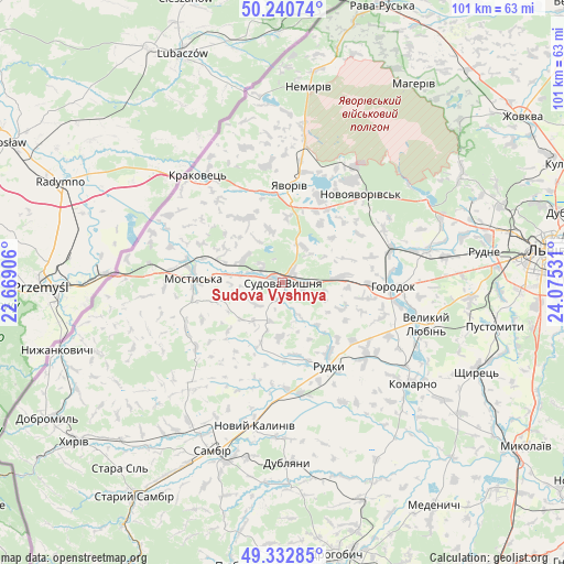
Sudova Vyshnya GPS coordinates[2]
49° 47' 20.112" North, 23° 22' 19.848" East
| Map corner | latitude | longitude |
|---|---|---|
| Upper-left | 50.24074°, | 22.66906° |
| Center: | 49.78892°, | 23.37218° |
| Lower-right: | 49.33285°, | 24.07531° |
| Map W x H: | 100.9×100.9 km | = 62.7×62.7mi |
| max Lat: | 52.18903° ⇑20.8% North |
| Sudova Vyshnya: | 49.78892° |
| min Lat: | ⇓79.2% South 44.39214° |
| min Long | Sudova Vyshnya | max Long |
| 22.20555° | 23.37218° | 40.13222° |
| W 3.3%⇐ | ⇒96.7% E |
Elevation
Elevation of Sudova Vyshnya is 216 m = 709 ft, and this is 60.2 m = 198 ft above average elevation for this country.
| Max E: |
886 m = 2907 ft | 27.1% |
| Sudova Vyshnya | 216 m 709 ft | |
| Avg. | 155.8 m = 511 ft | |
Min E: |
-3 m = -10 ft | 72.9% |
See also: Ukraine elevation on elevation.city.
Geographical zone
Sudova Vyshnya is located in North temperate zone (between Tropic of Cancer and the Arctic Circle). Distance of this North polar circle is 1865.2 km =1159 mi to North.| Distance of | km | miles | from Sudova Vyshnya |
|---|---|---|---|
| North Pole | 4471.1 | 2778.2 | to North |
| Arctic Circle | 1865.2 | 1159 | to North |
| Tropic Cancer | 2930.1 | 1820.7 | to South |
| Equator | 5536 | 3439.9 | to South |


Nearby cities:
15 places around Sudova Vyshnya: (largest is in red/bold)
• Horodok
19.8 km =12.3 mi,  91°
91°
• Ivano-Frankove
29.4 km =18.3 mi,  60°
60°
• Komarno
29.6 km =18.4 mi,  127°
127°
• Krukenychi
19.2 km =11.9 mi,  234°
234°
• Mostys'ka
15.9 km =9.9 mi,  272°
272°
• Novoyavorivs'k
21.3 km =13.2 mi,  42°
42°
• Pnikut
18.9 km =11.7 mi,  242°
242°
• Rodatychi
11.6 km =7.2 mi,  84°
84°
• Rudky
17.2 km =10.7 mi,  151°
151°
• Shklo
22.4 km =13.9 mi,  33°
33°
• Starychi
25.1 km =15.6 mi, 32°
• Tvirzha
9.9 km =6.2 mi,  279°
279°
• Verblyany
29 km =18 mi,  7°
7°
• Vereshitsa
28.9 km =18 mi, 40°
• Yavoriv
16.7 km =10.4 mi,  2°
2°
Sources, notices
• [Note1] Compared only with cities in Ukraine existing in our database
• [Src1] Map data: © OpenStreetMap contributors (CC-BY-SA)
• [Src2] Other city data from geonames.org with taken over terms of usage.
• [Src3] Geographical zone / Annual Mean Temperature by Robert A. Rohde @ Wikipedia
