Tvirzha geodata
Tvirzha (Lviv) is a populated place; located in Ukraine in Europe/Kiev (GMT+3) time zone. With population of 645 people, there are 1554 cities with bigger population in this country. Compared to other cities in Ukraine, 79.6% of cities are located further ↓South; 97.3% of cities are located further →East and 70% of cities have lower elevation than Tvirzha. Note1


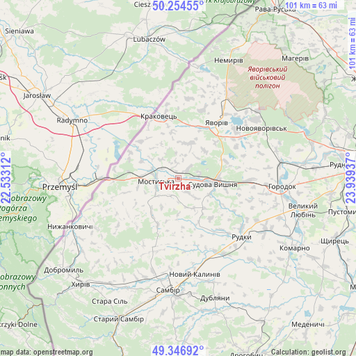
Tvirzha GPS coordinates[2]
49° 48' 10.296" North, 23° 14' 10.464" East
| Map corner | latitude | longitude |
|---|---|---|
| Upper-left | 50.25455°, | 22.53312° |
| Center: | 49.80286°, | 23.23624° |
| Lower-right: | 49.34692°, | 23.93937° |
| Map W x H: | 100.9×100.9 km | = 62.7×62.7mi |
| max Lat: | 52.18903° ⇑20.4% North |
| Tvirzha: | 49.80286° |
| min Lat: | ⇓79.6% South 44.39214° |
| min Long | Tvirzha | max Long |
| 22.20555° | 23.23624° | 40.13222° |
| W 2.7%⇐ | ⇒97.3% E |
Elevation
Elevation of Tvirzha is 206 m = 676 ft, and this is 50.2 m = 165 ft above average elevation for this country.
| Max E: |
886 m = 2907 ft | 30% |
| Tvirzha | 206 m 676 ft | |
| Avg. | 155.8 m = 511 ft | |
Min E: |
-3 m = -10 ft | 70% |
See also: Ukraine elevation on elevation.city.
Geographical zone
Tvirzha is located in North temperate zone (between Tropic of Cancer and the Arctic Circle). Distance of this North polar circle is 1863.6 km =1158 mi to North.| Distance of | km | miles | from Tvirzha |
|---|---|---|---|
| North Pole | 4469.5 | 2777.2 | to North |
| Arctic Circle | 1863.6 | 1158 | to North |
| Tropic Cancer | 2931.6 | 1821.6 | to South |
| Equator | 5537.6 | 3440.9 | to South |


Nearby cities:
15 places around Tvirzha: (largest is in red/bold)
• Horodok
29.6 km =18.4 mi,  93°
93°
• Krukenychi
14 km =8.7 mi,  204°
204°
• Mostys'ka
6.2 km =3.9 mi,  261°
261°
• Novoyavorivs'k
28 km =17.4 mi,  59°
59°
• Pnikut
12.4 km =7.7 mi,  214°
214°
• Ralivka
33.7 km =20.9 mi,  179°
179°
• Rodatychi
21.3 km =13.2 mi, 91°
• Rudky
24.5 km =15.2 mi,  132°
132°
• Sambir
31.8 km =19.8 mi,  185°
185°
• Shklo
27.9 km =17.3 mi,  52°
52°
• Starychi
30.3 km =18.8 mi, 49°
• Sudova Vyshnya
9.9 km =6.2 mi,  99°
99°
• Verblyany
30.3 km =18.8 mi,  26°
26°
• Voyutychi
29.5 km =18.3 mi, 198°
• Yavoriv
18.4 km =11.4 mi, 34°
Sources, notices
• [Note1] Compared only with cities in Ukraine existing in our database
• [Src1] Map data: © OpenStreetMap contributors (CC-BY-SA)
• [Src2] Other city data from geonames.org with taken over terms of usage.
• [Src3] Geographical zone / Annual Mean Temperature by Robert A. Rohde @ Wikipedia
