Rudky geodata
Rudky (Lviv) is a populated place; located in Ukraine in Europe/Kiev (GMT+3) time zone. With population of 4,912 people, there are 662 cities with bigger population in this country. Compared to other cities in Ukraine, 77.1% of cities are located further ↓South; 95.8% of cities are located further →East and 83.3% of cities have lower elevation than Rudky. Note1


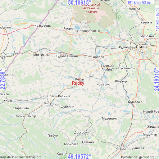
Rudky GPS coordinates[2]
49° 39' 11.016" North, 23° 29' 13.272" East
| Map corner | latitude | longitude |
|---|---|---|
| Upper-left | 50.10615°, | 22.7839° |
| Center: | 49.65306°, | 23.48702° |
| Lower-right: | 49.19572°, | 24.19015° |
| Map W x H: | 101.2×101.2 km | = 62.9×62.9mi |
| max Lat: | 52.18903° ⇑22.9% North |
| Rudky: | 49.65306° |
| min Lat: | ⇓77.1% South 44.39214° |
| min Long | Rudky | max Long |
| 22.20555° | 23.48702° | 40.13222° |
| W 4.2%⇐ | ⇒95.8% E |
Elevation
Elevation of Rudky is 265 m = 869 ft, and this is 109.2 m = 358 ft above average elevation for this country.
| Max E: |
886 m = 2907 ft | 16.7% |
| Rudky | 265 m 869 ft | |
| Avg. | 155.8 m = 511 ft | |
Min E: |
-3 m = -10 ft | 83.3% |
See also: Ukraine elevation on elevation.city.
Geographical zone
Rudky is located in North temperate zone (between Tropic of Cancer and the Arctic Circle). Distance of this North polar circle is 1880.3 km =1168.4 mi to North.| Distance of | km | miles | from Rudky |
|---|---|---|---|
| North Pole | 4486.2 | 2787.6 | to North |
| Arctic Circle | 1880.3 | 1168.4 | to North |
| Tropic Cancer | 2915 | 1811.3 | to South |
| Equator | 5520.9 | 3430.5 | to South |


Nearby cities:
15 places around Rudky: (largest is in red/bold)
• Dublyany
18.7 km =11.6 mi,  202°
202°
• Horodok
18.7 km =11.6 mi,  38°
38°
• Komarno
15.6 km =9.7 mi,  100°
100°
• Krukenychi
24.2 km =15 mi,  279°
279°
• Mostys'ka
28.8 km =17.9 mi,  303°
303°
• Obroshyne
30.9 km =19.2 mi,  62°
62°
• Pnikut
25.9 km =16.1 mi, 284°
• Ralivka
24.8 km =15.4 mi,  226°
226°
• Rodatychi
16.5 km =10.3 mi,  11°
11°
• Rykhtychi
30.2 km =18.8 mi,  170°
170°
• Sambir
25.7 km =16 mi, 234°
• Shchyrets
27.9 km =17.3 mi,  90°
90°
• Sudova Vyshnya
17.2 km =10.7 mi,  331°
331°
• Tvirzha
24.5 km =15.2 mi,  312°
312°
• Voyutychi
29.7 km =18.5 mi,  247°
247°
Sources, notices
• [Note1] Compared only with cities in Ukraine existing in our database
• [Src1] Map data: © OpenStreetMap contributors (CC-BY-SA)
• [Src2] Other city data from geonames.org with taken over terms of usage.
• [Src3] Geographical zone / Annual Mean Temperature by Robert A. Rohde @ Wikipedia
