Starychi geodata
Starychi (Lviv) is a populated place; located in Ukraine in Europe/Kiev (GMT+3) time zone. With population of 3,293 people, there are 868 cities with bigger population in this country. Compared to other cities in Ukraine, 83.4% of cities are located further ↓South; 95.2% of cities are located further →East and 86% of cities have lower elevation than Starychi. Note1


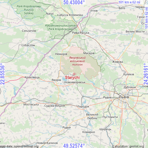
Starychi GPS coordinates[2]
49° 58' 48.036" North, 23° 33' 30.528" East
| Map corner | latitude | longitude |
|---|---|---|
| Upper-left | 50.43004°, | 22.85536° |
| Center: | 49.98001°, | 23.55848° |
| Lower-right: | 49.52574°, | 24.26161° |
| Map W x H: | 100.5×100.5 km | = 62.4×62.4mi |
| max Lat: | 52.18903° ⇑16.6% North |
| Starychi: | 49.98001° |
| min Lat: | ⇓83.4% South 44.39214° |
| min Long | Starychi | max Long |
| 22.20555° | 23.55848° | 40.13222° |
| W 4.8%⇐ | ⇒95.2% E |
Elevation
Elevation of Starychi is 281 m = 922 ft, and this is 125.2 m = 411 ft above average elevation for this country.
| Max E: |
886 m = 2907 ft | 14% |
| Starychi | 281 m 922 ft | |
| Avg. | 155.8 m = 511 ft | |
Min E: |
-3 m = -10 ft | 86% |
See also: Ukraine elevation on elevation.city.
Geographical zone
Starychi is located in North temperate zone (between Tropic of Cancer and the Arctic Circle). Distance of this North polar circle is 1843.9 km =1145.7 mi to North.| Distance of | km | miles | from Starychi |
|---|---|---|---|
| North Pole | 4449.8 | 2765 | to North |
| Arctic Circle | 1843.9 | 1145.7 | to North |
| Tropic Cancer | 2951.3 | 1833.9 | to South |
| Equator | 5557.3 | 3453.1 | to South |


Nearby cities:
15 places around Starychi: (largest is in red/bold)
• Hlyns'k
26 km =16.2 mi,  69°
69°
• Horodok
22.7 km =14.1 mi,  163°
163°
• Ivano-Frankove
13.9 km =8.6 mi,  118°
118°
• Krekhiv
20 km =12.4 mi, 66°
• Novoyavorivs'k
5.6 km =3.5 mi,  168°
168°
• Potelych
25.4 km =15.8 mi,  358°
358°
• Rava-Rus’ka
28.3 km =17.6 mi,  10°
10°
• Rodatychi
20.2 km =12.6 mi,  185°
185°
• Rudne
29.4 km =18.3 mi, 123°
• Shklo
2.8 km =1.7 mi,  201°
201°
• Sudova Vyshnya
25.1 km =15.6 mi,  212°
212°
• Sukhovolya
26.5 km =16.5 mi,  130°
130°
• Verblyany
12.3 km =7.6 mi,  307°
307°
• Vereshitsa
5.3 km =3.3 mi,  80°
80°
• Yavoriv
13.4 km =8.3 mi,  249°
249°
Sources, notices
• [Note1] Compared only with cities in Ukraine existing in our database
• [Src1] Map data: © OpenStreetMap contributors (CC-BY-SA)
• [Src2] Other city data from geonames.org with taken over terms of usage.
• [Src3] Geographical zone / Annual Mean Temperature by Robert A. Rohde @ Wikipedia
