Kochetok geodata
Kochetok (Kharkiv) is a populated place; located in Ukraine in Europe/Kiev (GMT+3) time zone. With population of 3,481 people, there are 838 cities with bigger population in this country. Compared to other cities in Ukraine, 81.3% of cities are located further ↓South; 90.3% of cities are located further ←West and 54.6% of cities have lower elevation than Kochetok. Note1


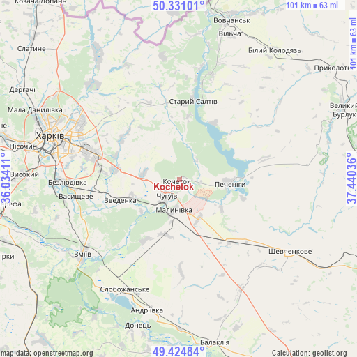
Kochetok GPS coordinates[2]
49° 52' 48.18" North, 36° 44' 14.028" East
| Map corner | latitude | longitude |
|---|---|---|
| Upper-left | 50.33101°, | 36.03411° |
| Center: | 49.88005°, | 36.73723° |
| Lower-right: | 49.42484°, | 37.44036° |
| Map W x H: | 100.8×100.8 km | = 62.6×62.6mi |
| max Lat: | 52.18903° ⇑18.7% North |
| Kochetok: | 49.88005° |
| min Lat: | ⇓81.3% South 44.39214° |
| min Long | Kochetok | max Long |
| 22.20555° | 36.73723° | 40.13222° |
| W 90.3%⇐ | ⇒9.7% E |
Elevation
Elevation of Kochetok is 151 m = 495 ft, and this is 4.8 m = 16 ft below average elevation for this country.
| Max E: |
886 m = 2907 ft | 45.4% |
| Avg. | 155.8 m = 511 ft | |
| Kochetok | 151 m = 495 ft | |
Min E: |
-3 m = -10 ft | 54.6% |
See also: Ukraine elevation on elevation.city.
Geographical zone
Kochetok is located in North temperate zone (between Tropic of Cancer and the Arctic Circle). Distance of this North polar circle is 1855 km =1152.6 mi to North.| Distance of | km | miles | from Kochetok |
|---|---|---|---|
| North Pole | 4460.9 | 2771.9 | to North |
| Arctic Circle | 1855 | 1152.6 | to North |
| Tropic Cancer | 2940.2 | 1827 | to South |
| Equator | 5546.1 | 3446.2 | to South |


Nearby cities:
15 places around Kochetok: (largest is in red/bold)
• Bezlyudivka
33.8 km =21 mi,  269°
269°
• Chuhuyiv
6 km =3.7 mi,  215°
215°
• Eskhar
14.1 km =8.8 mi,  228°
228°
• Kharkiv
36.4 km =22.6 mi,  287°
287°
• Kulynychi
27.8 km =17.3 mi, 294°
• Lyman
36.8 km =22.9 mi,  211°
211°
• Malynivka
7.1 km =4.4 mi,  182°
182°
• Novopokrovka
14.5 km =9 mi,  249°
249°
• Pechenihy
14.2 km =8.8 mi,  93°
93°
• Shevchenkove
37.4 km =23.2 mi,  123°
123°
• Slobozhans’ke
34.9 km =21.7 mi, 205°
• Staryy Saltiv
22.1 km =13.7 mi,  9°
9°
• Vasyshcheve
30 km =18.6 mi,  258°
258°
• Vvedenka
17.9 km =11.1 mi, 249°
• Zmiyiv
36.1 km =22.4 mi, 230°
Sources, notices
• [Note1] Compared only with cities in Ukraine existing in our database
• [Src1] Map data: © OpenStreetMap contributors (CC-BY-SA)
• [Src2] Other city data from geonames.org with taken over terms of usage.
• [Src3] Geographical zone / Annual Mean Temperature by Robert A. Rohde @ Wikipedia
