Pushkino geodata
Pushkino (Republic of Crimea) is a seat of a third-order administrative division; located in Ukraine in Europe/Simferopol (GMT+3) time zone. With population of 1,098 people, there are 1336 cities with bigger population in this country. Compared to other cities in Ukraine, 85.6% of cities are located further ↑North; 80.2% of cities are located further ←West and 74.2% of cities have higher elevation than Pushkino. Note1
Administrative division(s):
- Level 1: Republic of Crimea
- Level 2: Sovietskyi Raion
- Level 3: Pushkinskoye sel'skoye poselenye


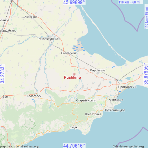
Pushkino GPS coordinates[2]
45° 12' 13.428" North, 34° 58' 35.112" East
| Map corner | latitude | longitude |
|---|---|---|
| Upper-left | 45.69699°, | 34.2733° |
| Center: | 45.20373°, | 34.97642° |
| Lower-right: | 44.70616°, | 35.67955° |
| Map W x H: | 110.2×110.2 km | = 68.5×68.5mi |
| max Lat: | 52.18903° ⇑85.6% North |
| Pushkino: | 45.20373° |
| min Lat: | ⇓14.4% South 44.39214° |
| min Long | Pushkino | max Long |
| 22.20555° | 34.97642° | 40.13222° |
| W 80.2%⇐ | ⇒19.8% E |
Elevation
Elevation of Pushkino is 63 m = 207 ft, and this is 92.8 m = 304 ft below average elevation for this country.
| Max E: |
886 m = 2907 ft | 74.2% |
| Avg. | 155.8 m = 511 ft | |
| Pushkino | 63 m = 207 ft | |
Min E: |
-3 m = -10 ft | 25.8% |
See also: Ukraine elevation on elevation.city.
Geographical zone
Pushkino is located in North temperate zone (between Tropic of Cancer and the Arctic Circle). Distance of this North polar circle is 2375 km =1475.8 mi to North.| Distance of | km | miles | from Pushkino |
|---|---|---|---|
| North Pole | 4980.9 | 3095 | to North |
| Arctic Circle | 2375 | 1475.8 | to North |
| Tropic Cancer | 2420.3 | 1503.9 | to South |
| Equator | 5026.2 | 3123.1 | to South |


Nearby cities:
15 places around Pushkino: (largest is in red/bold)
• Abrikosovka
14.5 km =9 mi,  137°
137°
• Chapayevka
10.7 km =6.6 mi,  323°
323°
• Ilyichevo
8.7 km =5.4 mi,  58°
58°
• Krasnoflotskoye
12.7 km =7.9 mi,  349°
349°
• Krasnogvardeyskoye
3 km =1.9 mi,  221°
221°
• L’govskoye
11.8 km =7.3 mi,  187°
187°
• Novy Mir
11.9 km =7.4 mi, 315°
• Partizany
15.5 km =9.6 mi,  115°
115°
• Privetnoye
11.4 km =7.1 mi,  145°
145°
• Sovetskiy
16 km =9.9 mi, 345°
• Trudolyubovka
13.9 km =8.6 mi,  83°
83°
• Varvarovka
14.6 km =9.1 mi,  335°
335°
• Vostochnoye
4.3 km =2.7 mi,  66°
66°
• Vozrozhdeniye
5.5 km =3.4 mi,  127°
127°
• Zolotoye Pole
8.5 km =5.3 mi,  172°
172°
Sources, notices
• [Note1] Compared only with cities in Ukraine existing in our database
• [Src1] Map data: © OpenStreetMap contributors (CC-BY-SA)
• [Src2] Other city data from geonames.org with taken over terms of usage.
• [Src3] Geographical zone / Annual Mean Temperature by Robert A. Rohde @ Wikipedia
