Zolotoye Pole geodata
Zolotoye Pole (Republic of Crimea) is a seat of a third-order administrative division; located in Ukraine in Europe/Simferopol (GMT+3) time zone. With population of 2,543 people, there are 1025 cities with bigger population in this country. Compared to other cities in Ukraine, 87.5% of cities are located further ↑North; 80.4% of cities are located further ←West and 55.4% of cities have higher elevation than Zolotoye Pole. Note1
Administrative division(s):
- Level 1: Republic of Crimea
- Level 2: Kirovske Raion
- Level 3: Zolotopolenskoye sel'skoye poselenye


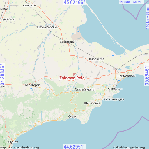
Zolotoye Pole GPS coordinates[2]
45° 7' 39.864" North, 34° 59' 29.328" East
| Map corner | latitude | longitude |
|---|---|---|
| Upper-left | 45.62166°, | 34.28836° |
| Center: | 45.12774°, | 34.99148° |
| Lower-right: | 44.62951°, | 35.69461° |
| Map W x H: | 110.3×110.3 km | = 68.5×68.5mi |
| max Lat: | 52.18903° ⇑87.5% North |
| Zolotoye Pole: | 45.12774° |
| min Lat: | ⇓12.5% South 44.39214° |
| min Long | Zolotoye Pole | max Long |
| 22.20555° | 34.99148° | 40.13222° |
| W 80.4%⇐ | ⇒19.6% E |
Elevation
Elevation of Zolotoye Pole is 119 m = 390 ft, and this is 36.8 m = 121 ft below average elevation for this country.
| Max E: |
886 m = 2907 ft | 55.4% |
| Avg. | 155.8 m = 511 ft | |
| Zolotoye Pole | 119 m = 390 ft | |
Min E: |
-3 m = -10 ft | 44.6% |
See also: Ukraine elevation on elevation.city.
Geographical zone
Zolotoye Pole is located in North temperate zone (between Tropic of Cancer and the Arctic Circle). Distance of this North polar circle is 2383.4 km =1481 mi to North.| Distance of | km | miles | from Zolotoye Pole |
|---|---|---|---|
| North Pole | 4989.3 | 3100.2 | to North |
| Arctic Circle | 2383.4 | 1481 | to North |
| Tropic Cancer | 2411.8 | 1498.6 | to South |
| Equator | 5017.7 | 3117.9 | to South |


Nearby cities:
15 places around Zolotoye Pole: (largest is in red/bold)
• Abrikosovka
8.9 km =5.5 mi,  104°
104°
• Babenkovo
11.4 km =7.1 mi,  107°
107°
• Grushevka
11.8 km =7.3 mi,  187°
187°
• Ilyichevo
14.5 km =9 mi,  25°
25°
• Kholodovka
8.4 km =5.2 mi,  179°
179°
• Krasnogvardeyskoye
7 km =4.3 mi,  332°
332°
• Kurskoye
11.8 km =7.3 mi,  201°
201°
• L’govskoye
4.2 km =2.6 mi,  218°
218°
• Muromskoye
11.9 km =7.4 mi,  249°
249°
• Partizany
13 km =8.1 mi,  82°
82°
• Privetnoye
5.4 km =3.4 mi, 99°
• Pushkino
8.5 km =5.3 mi,  352°
352°
• Stary Krym
13.5 km =8.4 mi,  144°
144°
• Vostochnoye
10.5 km =6.5 mi,  15°
15°
• Vozrozhdeniye
6 km =3.7 mi, 32°
Sources, notices
• [Note1] Compared only with cities in Ukraine existing in our database
• [Src1] Map data: © OpenStreetMap contributors (CC-BY-SA)
• [Src2] Other city data from geonames.org with taken over terms of usage.
• [Src3] Geographical zone / Annual Mean Temperature by Robert A. Rohde @ Wikipedia
