Vodnoye geodata
Vodnoye (Republic of Crimea) is a populated place; located in Ukraine in Europe/Simferopol (GMT+3) time zone. With population of 875 people, there are 1449 cities with bigger population in this country. Compared to other cities in Ukraine, 92.5% of cities are located further ↑North; 58.9% of cities are located further ←West and 53.1% of cities have higher elevation than Vodnoye. Note1
Administrative division(s):
- Level 1: Republic of Crimea
- Level 2: Simferopol Raion
- Level 3: Pozharskoye sel'skoye poselenye


Vodnoye GPS coordinates[2]
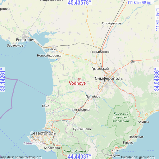
44° 56' 24.828" North, 33° 50' 44.628" East
| Map corner | latitude | longitude |
|---|---|---|
| Upper-left | 45.43578°, | 33.14261° |
| Center: | 44.94023°, | 33.84573° |
| Lower-right: | 44.44037°, | 34.54886° |
| Map W x H: | 110.7×110.7 km | = 68.8×68.8mi |
| max Lat: | 52.18903° ⇑92.5% North |
| Vodnoye: | 44.94023° |
| min Lat: | ⇓7.5% South 44.39214° |
| min Long | Vodnoye | max Long |
| 22.20555° | 33.84573° | 40.13222° |
| W 58.9%⇐ | ⇒41.1% E |
Elevation
Elevation of Vodnoye is 125 m = 410 ft, and this is 30.8 m = 101 ft below average elevation for this country.
| Max E: |
886 m = 2907 ft | 53.1% |
| Avg. | 155.8 m = 511 ft | |
| Vodnoye | 125 m = 410 ft | |
Min E: |
-3 m = -10 ft | 46.9% |
See also: Ukraine elevation on elevation.city.
Geographical zone
Vodnoye is located in North temperate zone (between Tropic of Cancer and the Arctic Circle). Distance of this Northern Tropic circle is 2391 km =1485.7 mi to South.| Distance of | km | miles | from Vodnoye |
|---|---|---|---|
| North Pole | 5010.2 | 3113.2 | to North |
| Arctic Circle | 2404.3 | 1494 | to North |
| Tropic Cancer | 2391 | 1485.7 | to South |
| Equator | 4996.9 | 3104.9 | to South |


Nearby cities:
15 places around Vodnoye: (largest is in red/bold)
• Arkadyevka
11.9 km =7.4 mi,  27°
27°
• Bryanskoye
8.9 km =5.5 mi,  201°
201°
• Kashtany
9.2 km =5.7 mi,  208°
208°
• Kolodeznoye
9.2 km =5.7 mi,  353°
353°
• Kol’chugino
4.5 km =2.8 mi,  274°
274°
• Lekarstvennoye
1.9 km =1.2 mi,  275°
275°
• Novosyolovka
6 km =3.7 mi, 352°
• Novovasilyevka
11.6 km =7.2 mi,  151°
151°
• Plodovoye
7.7 km =4.8 mi,  173°
173°
• Pozharskoye
2.1 km =1.3 mi,  104°
104°
• Prudovoye
6.5 km =4 mi,  231°
231°
• Ravnopolye
10.3 km =6.4 mi,  263°
263°
• Razdolye
12.5 km =7.8 mi,  287°
287°
• Shevchenkovo
11 km =6.8 mi,  218°
218°
• Vinnitskoye
9.5 km =5.9 mi,  298°
298°
Sources, notices
• [Note1] Compared only with cities in Ukraine existing in our database
• [Src1] Map data: © OpenStreetMap contributors (CC-BY-SA)
• [Src2] Other city data from geonames.org with taken over terms of usage.
• [Src3] Geographical zone / Annual Mean Temperature by Robert A. Rohde @ Wikipedia
