Razdolye geodata
Razdolye (Republic of Crimea) is a populated place; located in Ukraine in Europe/Simferopol (GMT+3) time zone. With population of 949 people, there are 1404 cities with bigger population in this country. Compared to other cities in Ukraine, 91.9% of cities are located further ↑North; 55.4% of cities are located further ←West and 76.1% of cities have higher elevation than Razdolye. Note1
Administrative division(s):
- Level 1: Republic of Crimea
- Level 2: Simferopol Raion
- Level 3: Nikolaevskoye sel'skoye poselenye


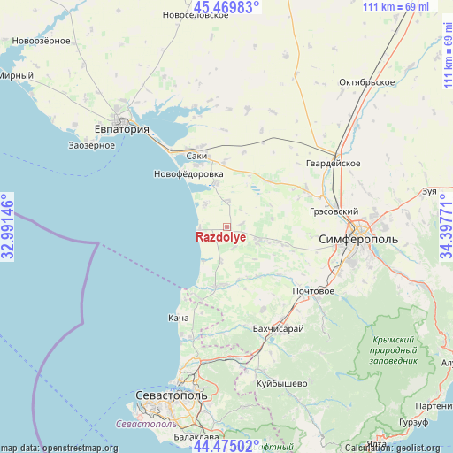
Razdolye GPS coordinates[2]
44° 58' 28.488" North, 33° 41' 40.488" East
| Map corner | latitude | longitude |
|---|---|---|
| Upper-left | 45.46983°, | 32.99146° |
| Center: | 44.97458°, | 33.69458° |
| Lower-right: | 44.47502°, | 34.39771° |
| Map W x H: | 110.6×110.6 km | = 68.7×68.7mi |
| max Lat: | 52.18903° ⇑91.9% North |
| Razdolye: | 44.97458° |
| min Lat: | ⇓8.1% South 44.39214° |
| min Long | Razdolye | max Long |
| 22.20555° | 33.69458° | 40.13222° |
| W 55.4%⇐ | ⇒44.6% E |
Elevation
Elevation of Razdolye is 57 m = 187 ft, and this is 98.8 m = 324 ft below average elevation for this country.
| Max E: |
886 m = 2907 ft | 76.1% |
| Avg. | 155.8 m = 511 ft | |
| Razdolye | 57 m = 187 ft | |
Min E: |
-3 m = -10 ft | 23.9% |
See also: Ukraine elevation on elevation.city.
Geographical zone
Razdolye is located in North temperate zone (between Tropic of Cancer and the Arctic Circle). Distance of this Northern Tropic circle is 2394.8 km =1488.1 mi to South.| Distance of | km | miles | from Razdolye |
|---|---|---|---|
| North Pole | 5006.4 | 3110.8 | to North |
| Arctic Circle | 2400.5 | 1491.6 | to North |
| Tropic Cancer | 2394.8 | 1488.1 | to South |
| Equator | 5000.7 | 3107.3 | to South |


Nearby cities:
15 places around Razdolye: (largest is in red/bold)
• Beregovoye
10.3 km =6.4 mi,  216°
216°
• Frunze
7.7 km =4.8 mi,  318°
318°
• Ivanovka
11.1 km =6.9 mi,  346°
346°
• Kolodeznoye
12 km =7.5 mi,  63°
63°
• Kol’chugino
8.2 km =5.1 mi,  114°
114°
• Lekarstvennoye
10.7 km =6.6 mi, 109°
• Nikolayevka
6.7 km =4.2 mi,  258°
258°
• Novosyolovka
11.3 km =7 mi,  79°
79°
• Otradnoye
12.9 km =8 mi,  167°
167°
• Prudovoye
10.4 km =6.5 mi,  138°
138°
• Ravnopolye
5.2 km =3.2 mi,  161°
161°
• Tabachnoye
8.2 km =5.1 mi,  190°
190°
• Teplovka
6.4 km =4 mi,  0°
0°
• Vinnitskoye
3.6 km =2.2 mi, 77°
• Vodnoye
12.5 km =7.8 mi, 107°
Sources, notices
• [Note1] Compared only with cities in Ukraine existing in our database
• [Src1] Map data: © OpenStreetMap contributors (CC-BY-SA)
• [Src2] Other city data from geonames.org with taken over terms of usage.
• [Src3] Geographical zone / Annual Mean Temperature by Robert A. Rohde @ Wikipedia
