Vladislavovka geodata
Vladislavovka (Republic of Crimea) is a populated place; located in Ukraine in Europe/Simferopol (GMT+3) time zone. With population of 839 people, there are 1465 cities with bigger population in this country. Compared to other cities in Ukraine, 77.9% of cities are located further ↑North; 74.4% of cities are located further ←West and 85.5% of cities have higher elevation than Vladislavovka. Note1
Administrative division(s):
- Level 1: Republic of Crimea
- Level 2: Nizhnegorskiy rayon
- Level 3: Novogrigoryevskoye sel'skoye poselenye


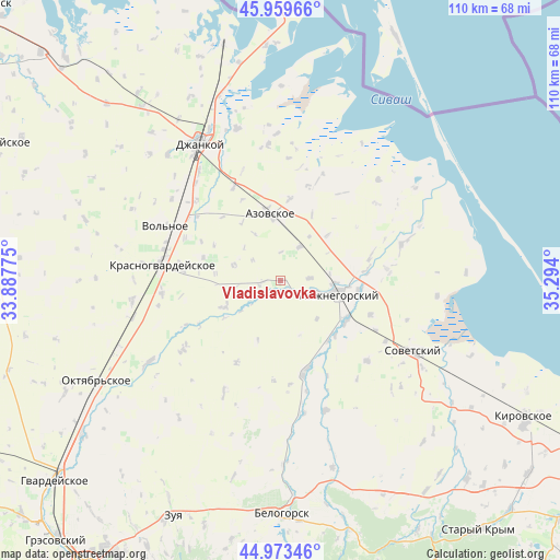
Vladislavovka GPS coordinates[2]
45° 28' 7.392" North, 34° 35' 27.132" East
| Map corner | latitude | longitude |
|---|---|---|
| Upper-left | 45.95966°, | 33.88775° |
| Center: | 45.46872°, | 34.59087° |
| Lower-right: | 44.97346°, | 35.294° |
| Map W x H: | 109.7×109.7 km | = 68.2×68.2mi |
| max Lat: | 52.18903° ⇑77.9% North |
| Vladislavovka: | 45.46872° |
| min Lat: | ⇓22.1% South 44.39214° |
| min Long | Vladislavovka | max Long |
| 22.20555° | 34.59087° | 40.13222° |
| W 74.4%⇐ | ⇒25.6% E |
Elevation
Elevation of Vladislavovka is 29 m = 95 ft, and this is 126.8 m = 416 ft below average elevation for this country.
| Max E: |
886 m = 2907 ft | 85.5% |
| Avg. | 155.8 m = 511 ft | |
| Vladislavovka | 29 m = 95 ft | |
Min E: |
-3 m = -10 ft | 14.5% |
See also: Ukraine elevation on elevation.city.
Geographical zone
Vladislavovka is located in North temperate zone (between Tropic of Cancer and the Arctic Circle). Distance of this North polar circle is 2345.5 km =1457.4 mi to North.| Distance of | km | miles | from Vladislavovka |
|---|---|---|---|
| North Pole | 4951.4 | 3076.7 | to North |
| Arctic Circle | 2345.5 | 1457.4 | to North |
| Tropic Cancer | 2449.7 | 1522.2 | to South |
| Equator | 5055.6 | 3141.4 | to South |


Nearby cities:
15 places around Vladislavovka: (largest is in red/bold)
• Azovskoye
13.2 km =8.2 mi,  351°
351°
• Klimovo
9.5 km =5.9 mi,  288°
288°
• Lomonosovo
10.4 km =6.5 mi,  135°
135°
• Mayskoye
14.4 km =8.9 mi, 347°
• Mikhaylovka
7.7 km =4.8 mi,  30°
30°
• Mitrofanovka
7.1 km =4.4 mi,  105°
105°
• Muskatnoye
3.7 km =2.3 mi,  265°
265°
• Nizhnegorskiy
11.7 km =7.3 mi,  101°
101°
• Novogrigoryevka
2.1 km =1.3 mi,  151°
151°
• Novopokrovka
12.1 km =7.5 mi,  244°
244°
• Plodovoye
10.3 km =6.4 mi, 101°
• Razlivy
10.1 km =6.3 mi,  94°
94°
• Semennoye
13.4 km =8.3 mi, 95°
• Zelyonoye
11.1 km =6.9 mi, 91°
• Zorkino
12.8 km =8 mi,  46°
46°
Sources, notices
• [Note1] Compared only with cities in Ukraine existing in our database
• [Src1] Map data: © OpenStreetMap contributors (CC-BY-SA)
• [Src2] Other city data from geonames.org with taken over terms of usage.
• [Src3] Geographical zone / Annual Mean Temperature by Robert A. Rohde @ Wikipedia
