Novogrigoryevka geodata
Novogrigoryevka (Republic of Crimea) is a seat of a third-order administrative division; located in Ukraine in Europe/Simferopol (GMT+3) time zone. With population of 1,002 people, there are 1380 cities with bigger population in this country. Compared to other cities in Ukraine, 78.4% of cities are located further ↑North; 74.8% of cities are located further ←West and 85.5% of cities have higher elevation than Novogrigoryevka. Note1
Administrative division(s):
- Level 1: Republic of Crimea
- Level 2: Nizhnegorskiy rayon
- Level 3: Novogrigoryevskoye sel'skoye poselenye


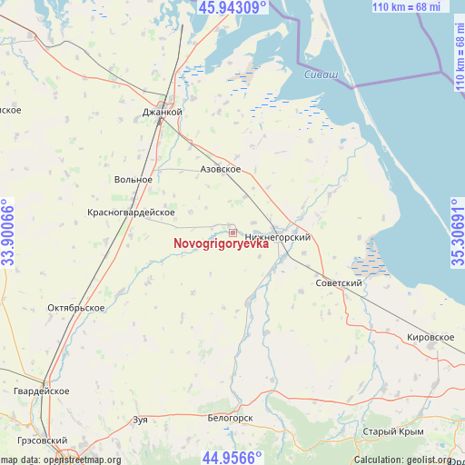
Novogrigoryevka GPS coordinates[2]
45° 27' 7.2" North, 34° 36' 13.608" East
| Map corner | latitude | longitude |
|---|---|---|
| Upper-left | 45.94309°, | 33.90066° |
| Center: | 45.452°, | 34.60378° |
| Lower-right: | 44.9566°, | 35.30691° |
| Map W x H: | 109.7×109.7 km | = 68.2×68.2mi |
| max Lat: | 52.18903° ⇑78.4% North |
| Novogrigoryevka: | 45.452° |
| min Lat: | ⇓21.6% South 44.39214° |
| min Long | Novogrigoryevka | max Long |
| 22.20555° | 34.60378° | 40.13222° |
| W 74.8%⇐ | ⇒25.2% E |
Elevation
Elevation of Novogrigoryevka is 29 m = 95 ft, and this is 126.8 m = 416 ft below average elevation for this country.
| Max E: |
886 m = 2907 ft | 85.5% |
| Avg. | 155.8 m = 511 ft | |
| Novogrigoryevka | 29 m = 95 ft | |
Min E: |
-3 m = -10 ft | 14.5% |
See also: Ukraine elevation on elevation.city.
Geographical zone
Novogrigoryevka is located in North temperate zone (between Tropic of Cancer and the Arctic Circle). Distance of this North polar circle is 2347.4 km =1458.6 mi to North.| Distance of | km | miles | from Novogrigoryevka |
|---|---|---|---|
| North Pole | 4953.3 | 3077.8 | to North |
| Arctic Circle | 2347.4 | 1458.6 | to North |
| Tropic Cancer | 2447.9 | 1521.1 | to South |
| Equator | 5053.8 | 3140.3 | to South |


Nearby cities:
15 places around Novogrigoryevka: (largest is in red/bold)
• Ivanovka
12.5 km =7.8 mi,  133°
133°
• Klimovo
11.2 km =7 mi,  295°
295°
• Lomonosovo
8.4 km =5.2 mi, 131°
• Mikhaylovka
9 km =5.6 mi,  18°
18°
• Mitrofanovka
5.9 km =3.7 mi,  90°
90°
• Muskatnoye
5 km =3.1 mi,  288°
288°
• Nizhnegorskiy
10.5 km =6.5 mi, 92°
• Novopokrovka
12.4 km =7.7 mi,  254°
254°
• Plodovoye
9.1 km =5.7 mi, 91°
• Razlivy
9.1 km =5.7 mi,  83°
83°
• Semennoye
12.3 km =7.6 mi, 86°
• Vladislavovka
2.1 km =1.3 mi,  331°
331°
• Zarech’ye
13 km =8.1 mi,  140°
140°
• Zelyonoye
10.2 km =6.3 mi, 81°
• Zhelyabovka
13.4 km =8.3 mi,  116°
116°
Sources, notices
• [Note1] Compared only with cities in Ukraine existing in our database
• [Src1] Map data: © OpenStreetMap contributors (CC-BY-SA)
• [Src2] Other city data from geonames.org with taken over terms of usage.
• [Src3] Geographical zone / Annual Mean Temperature by Robert A. Rohde @ Wikipedia
