Blizhneye geodata
Blizhneye (Republic of Crimea) is a populated place; located in Ukraine in Europe/Simferopol (GMT+3) time zone. With population of 2,779 people, there are 993 cities with bigger population in this country. Compared to other cities in Ukraine, 89.3% of cities are located further ↑North; 83.6% of cities are located further ←West and 86.4% of cities have higher elevation than Blizhneye. Note1


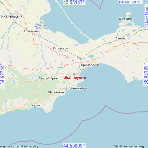
Blizhneye GPS coordinates[2]
45° 3' 24.984" North, 35° 19' 50.016" East
| Map corner | latitude | longitude |
|---|---|---|
| Upper-left | 45.55147°, | 34.62744° |
| Center: | 45.05694°, | 35.33056° |
| Lower-right: | 44.55809°, | 36.03369° |
| Map W x H: | 110.5×110.5 km | = 68.7×68.7mi |
| max Lat: | 52.18903° ⇑89.3% North |
| Blizhneye: | 45.05694° |
| min Lat: | ⇓10.7% South 44.39214° |
| min Long | Blizhneye | max Long |
| 22.20555° | 35.33056° | 40.13222° |
| W 83.6%⇐ | ⇒16.4% E |
Elevation
Elevation of Blizhneye is 26 m = 85 ft, and this is 129.8 m = 426 ft below average elevation for this country.
| Max E: |
886 m = 2907 ft | 86.4% |
| Avg. | 155.8 m = 511 ft | |
| Blizhneye | 26 m = 85 ft | |
Min E: |
-3 m = -10 ft | 13.6% |
See also: Ukraine elevation on elevation.city.
Geographical zone
Blizhneye is located in North temperate zone (between Tropic of Cancer and the Arctic Circle). Distance of this North polar circle is 2391.3 km =1485.9 mi to North.| Distance of | km | miles | from Blizhneye |
|---|---|---|---|
| North Pole | 4997.2 | 3105.1 | to North |
| Arctic Circle | 2391.3 | 1485.9 | to North |
| Tropic Cancer | 2403.9 | 1493.7 | to South |
| Equator | 5009.9 | 3113 | to South |


Nearby cities:
15 places around Blizhneye: (largest is in red/bold)
• Babenkovo
16.4 km =10.2 mi,  285°
285°
• Beregovoye
9.1 km =5.7 mi,  62°
62°
• Feodosiya
4.3 km =2.7 mi,  121°
121°
• Izyumovka
15.3 km =9.5 mi,  264°
264°
• Koktebel
12.5 km =7.8 mi,  211°
211°
• Nasypnoe
2.9 km =1.8 mi, 260°
• Novopokrovka
13.5 km =8.4 mi,  333°
333°
• Ordzhonikidze
10.5 km =6.5 mi,  169°
169°
• Partizany
16.8 km =10.4 mi,  305°
305°
• Pervomayskoye
13.1 km =8.1 mi,  272°
272°
• Primorskiy
13.6 km =8.5 mi, 59°
• Shchebetovka
18.9 km =11.7 mi,  225°
225°
• Solnechnoye
1.6 km =1 mi,  132°
132°
• Vladislavovka
12.9 km =8 mi,  16°
16°
• Zhuravki
11.9 km =7.4 mi, 310°
Sources, notices
• [Note1] Compared only with cities in Ukraine existing in our database
• [Src1] Map data: © OpenStreetMap contributors (CC-BY-SA)
• [Src2] Other city data from geonames.org with taken over terms of usage.
• [Src3] Geographical zone / Annual Mean Temperature by Robert A. Rohde @ Wikipedia
