Primorskiy geodata
Primorskiy (Republic of Crimea) is a populated place; located in Ukraine in Europe/Simferopol (GMT+3) time zone. With population of 12,560 people, there are 298 cities with bigger population in this country. Compared to other cities in Ukraine, 87.9% of cities are located further ↑North; 84.5% of cities are located further ←West and 93.7% of cities have higher elevation than Primorskiy. Note1


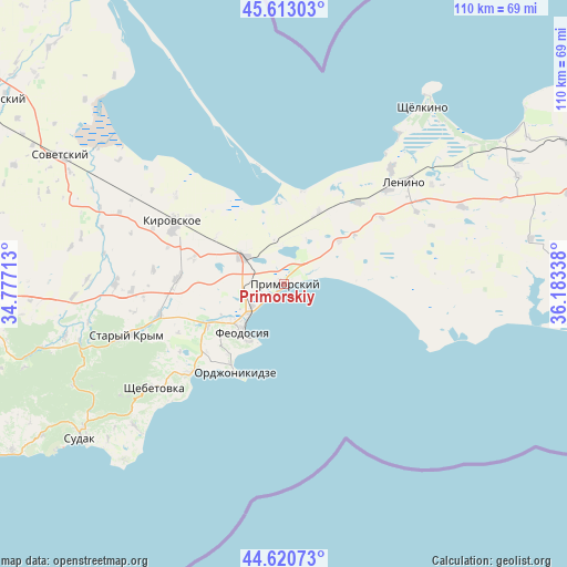
Primorskiy GPS coordinates[2]
45° 7' 8.544" North, 35° 28' 48.9" East
| Map corner | latitude | longitude |
|---|---|---|
| Upper-left | 45.61303°, | 34.77713° |
| Center: | 45.11904°, | 35.48025° |
| Lower-right: | 44.62073°, | 36.18338° |
| Map W x H: | 110.3×110.3 km | = 68.5×68.5mi |
| max Lat: | 52.18903° ⇑87.9% North |
| Primorskiy: | 45.11904° |
| min Lat: | ⇓12.1% South 44.39214° |
| min Long | Primorskiy | max Long |
| 22.20555° | 35.48025° | 40.13222° |
| W 84.5%⇐ | ⇒15.5% E |
Elevation
Elevation of Primorskiy is 14 m = 46 ft, and this is 141.8 m = 465 ft below average elevation for this country.
| Max E: |
886 m = 2907 ft | 93.7% |
| Avg. | 155.8 m = 511 ft | |
| Primorskiy | 14 m = 46 ft | |
Min E: |
-3 m = -10 ft | 6.3% |
See also: Ukraine elevation on elevation.city.
Geographical zone
Primorskiy is located in North temperate zone (between Tropic of Cancer and the Arctic Circle). Distance of this North polar circle is 2384.4 km =1481.6 mi to North.| Distance of | km | miles | from Primorskiy |
|---|---|---|---|
| North Pole | 4990.3 | 3100.8 | to North |
| Arctic Circle | 2384.4 | 1481.6 | to North |
| Tropic Cancer | 2410.8 | 1498 | to South |
| Equator | 5016.8 | 3117.3 | to South |


Nearby cities:
15 places around Primorskiy: (largest is in red/bold)
• Batal’noye
13.5 km =8.4 mi,  51°
51°
• Beregovoye
4.5 km =2.8 mi,  233°
233°
• Blizhneye
13.6 km =8.5 mi,  239°
239°
• Feodosiya
12.2 km =7.6 mi,  221°
221°
• Lugovoye
22.9 km =14.2 mi,  55°
55°
• Nasypnoe
16.4 km =10.2 mi, 243°
• Novopokrovka
18.5 km =11.5 mi,  286°
286°
• Ordzhonikidze
19.8 km =12.3 mi,  209°
209°
• Semisotka
15.7 km =9.8 mi,  25°
25°
• Sinitsyno
22.6 km =14 mi,  305°
305°
• Solnechnoye
13.3 km =8.3 mi, 232°
• Uvarovo
21.6 km =13.4 mi,  42°
42°
• Vladislavovka
9.8 km =6.1 mi,  303°
303°
• Yarkoye Pole
24.1 km =15 mi, 293°
• Zhuravki
20.8 km =12.9 mi,  272°
272°
Sources, notices
• [Note1] Compared only with cities in Ukraine existing in our database
• [Src1] Map data: © OpenStreetMap contributors (CC-BY-SA)
• [Src2] Other city data from geonames.org with taken over terms of usage.
• [Src3] Geographical zone / Annual Mean Temperature by Robert A. Rohde @ Wikipedia
