Plotinnoye geodata
Plotinnoye (Republic of Crimea) is a populated place; located in Ukraine in Europe/Simferopol (GMT+3) time zone. With population of 663 people, there are 1546 cities with bigger population in this country. Compared to other cities in Ukraine, 98.1% of cities are located further ↑North; 61.6% of cities are located further ←West and 80.9% of cities have lower elevation than Plotinnoye. Note1
Administrative division(s):
- Level 1: Republic of Crimea
- Level 2: Bakhchysarai Raion
- Level 3: Zelenovskoye sel'skoye poselenye


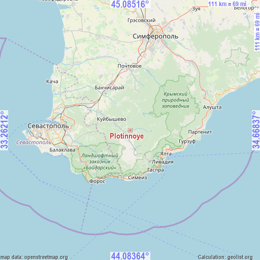
Plotinnoye GPS coordinates[2]
44° 35' 11.616" North, 33° 57' 54.864" East
| Map corner | latitude | longitude |
|---|---|---|
| Upper-left | 45.08516°, | 33.26212° |
| Center: | 44.58656°, | 33.96524° |
| Lower-right: | 44.08364°, | 34.66837° |
| Map W x H: | 111.4×111.4 km | = 69.2×69.2mi |
| max Lat: | 52.18903° ⇑98.1% North |
| Plotinnoye: | 44.58656° |
| min Lat: | ⇓1.9% South 44.39214° |
| min Long | Plotinnoye | max Long |
| 22.20555° | 33.96524° | 40.13222° |
| W 61.6%⇐ | ⇒38.4% E |
Elevation
Elevation of Plotinnoye is 251 m = 823 ft, and this is 95.2 m = 312 ft above average elevation for this country.
| Max E: |
886 m = 2907 ft | 19.1% |
| Plotinnoye | 251 m 823 ft | |
| Avg. | 155.8 m = 511 ft | |
Min E: |
-3 m = -10 ft | 80.9% |
See also: Ukraine elevation on elevation.city.
Geographical zone
Plotinnoye is located in North temperate zone (between Tropic of Cancer and the Arctic Circle). Distance of this Northern Tropic circle is 2351.6 km =1461.2 mi to South.| Distance of | km | miles | from Plotinnoye |
|---|---|---|---|
| North Pole | 5049.5 | 3137.6 | to North |
| Arctic Circle | 2443.6 | 1518.4 | to North |
| Tropic Cancer | 2351.6 | 1461.2 | to South |
| Equator | 4957.6 | 3080.5 | to South |


Nearby cities:
15 places around Plotinnoye: (largest is in red/bold)
• Golubinka
4 km =2.5 mi,  281°
281°
• Krasnyi Mak
15.8 km =9.8 mi,  293°
293°
• Kuibyshevo
9 km =5.6 mi,  301°
301°
• Nauchny
15.9 km =9.9 mi,  12°
12°
• Peredovoye
13.8 km =8.6 mi,  231°
231°
• Predushchel’noye
15.3 km =9.5 mi,  330°
330°
• Rodnikovoye
16.3 km =10.1 mi,  213°
213°
• Rodnoye
18.3 km =11.4 mi,  258°
258°
• Sokolinoye
4.1 km =2.5 mi,  187°
187°
• Tankovoye
14.7 km =9.1 mi, 302°
• Ternovka
17 km =10.6 mi,  267°
267°
• Turgenevka
16.3 km =10.1 mi,  319°
319°
• Verkhorechye
12.4 km =7.7 mi, 7°
• Vinogradnoye
17.5 km =10.9 mi,  131°
131°
• Zelyonoye
3.6 km =2.2 mi,  73°
73°
Sources, notices
• [Note1] Compared only with cities in Ukraine existing in our database
• [Src1] Map data: © OpenStreetMap contributors (CC-BY-SA)
• [Src2] Other city data from geonames.org with taken over terms of usage.
• [Src3] Geographical zone / Annual Mean Temperature by Robert A. Rohde @ Wikipedia
