Velykyi Bereznyi geodata
Velykyi Bereznyi (Transcarpathia) is a populated place; located in Ukraine in Europe/Uzhgorod (GMT+3) time zone. With population of 7,078 people, there are 503 cities with bigger population in this country. Compared to other cities in Ukraine, 63.5% of cities are located further ↓South; 99.5% of cities are located further →East and 67.8% of cities have lower elevation than Velykyi Bereznyi. Note1


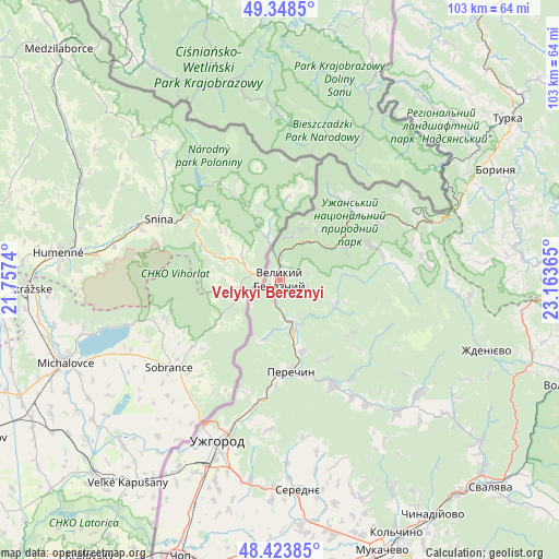
Velykyi Bereznyi GPS coordinates[2]
48° 53' 17.916" North, 22° 27' 37.872" East
| Map corner | latitude | longitude |
|---|---|---|
| Upper-left | 49.3485°, | 21.7574° |
| Center: | 48.88831°, | 22.46052° |
| Lower-right: | 48.42385°, | 23.16365° |
| Map W x H: | 102.8×102.8 km | = 63.9×63.9mi |
| max Lat: | 52.18903° ⇑36.5% North |
| Velykyi Bereznyi: | 48.88831° |
| min Lat: | ⇓63.5% South 44.39214° |
| min Long | Velykyi Berezny | max Long |
| 22.20555° | 22.46052° | 40.13222° |
| W 0.5%⇐ | ⇒99.5% E |
Elevation
Elevation of Velykyi Bereznyi is 197 m = 646 ft, and this is 41.2 m = 135 ft above average elevation for this country.
| Max E: |
886 m = 2907 ft | 32.2% |
| Velykyi Bereznyi | 197 m 646 ft | |
| Avg. | 155.8 m = 511 ft | |
Min E: |
-3 m = -10 ft | 67.8% |
See also: Ukraine elevation on elevation.city.
Geographical zone
Velykyi Bereznyi is located in North temperate zone (between Tropic of Cancer and the Arctic Circle). Distance of this North polar circle is 1965.3 km =1221.2 mi to North.| Distance of | km | miles | from Velykyi Bereznyi |
|---|---|---|---|
| North Pole | 4571.2 | 2840.4 | to North |
| Arctic Circle | 1965.3 | 1221.2 | to North |
| Tropic Cancer | 2830 | 1758.5 | to South |
| Equator | 5435.9 | 3377.7 | to South |


Nearby cities:
15 places around Velykyi Bereznyi: (largest is in red/bold)
• Chop
54.1 km =33.6 mi,  200°
200°
• Chynadiyovo
52.4 km =32.6 mi,  149°
149°
• Kamianytsia
22.2 km =13.8 mi,  192°
192°
• Mukacheve
53.4 km =33.2 mi,  159°
159°
• Mynay
36 km =22.4 mi, 202°
• Nevyts’ke
24.3 km =15.1 mi, 192°
• Nove Davydkovo
51.1 km =31.8 mi,  166°
166°
• Onokivtsi
27.1 km =16.8 mi, 198°
• Perechyn
17 km =10.6 mi, 174°
• Poroshkovo
32.5 km =20.2 mi,  138°
138°
• Rakoshyno
47.9 km =29.8 mi, 167°
• Serednye
38.8 km =24.1 mi, 174°
• Storozhnytsya
35.8 km =22.2 mi,  207°
207°
• Turka
50.9 km =31.6 mi,  54°
54°
• Uzhgorod
32.4 km =20.1 mi, 201°
Sources, notices
• [Note1] Compared only with cities in Ukraine existing in our database
• [Src1] Map data: © OpenStreetMap contributors (CC-BY-SA)
• [Src2] Other city data from geonames.org with taken over terms of usage.
• [Src3] Geographical zone / Annual Mean Temperature by Robert A. Rohde @ Wikipedia
