Tabachnoye geodata
Tabachnoye (Republic of Crimea) is a seat of a third-order administrative division; located in Ukraine in Europe/Simferopol (GMT+3) time zone. With population of 1,597 people, there are 1193 cities with bigger population in this country. Compared to other cities in Ukraine, 93.2% of cities are located further ↑North; 54.9% of cities are located further ←West and 79% of cities have higher elevation than Tabachnoye. Note1
Administrative division(s):
- Level 1: Republic of Crimea
- Level 2: Bakhchysarai Raion
- Level 3: Tabachnenskoye sel'skoye poselenye


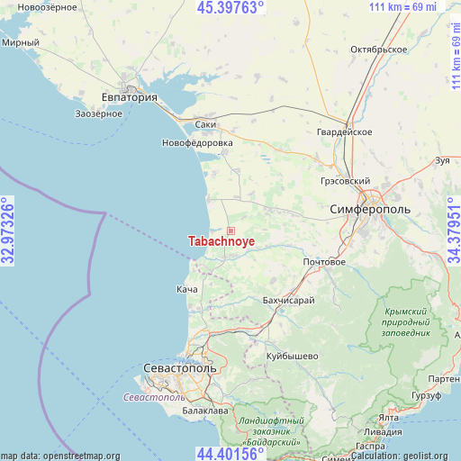
Tabachnoye GPS coordinates[2]
44° 54' 6.3" North, 33° 40' 34.968" East
| Map corner | latitude | longitude |
|---|---|---|
| Upper-left | 45.39763°, | 32.97326° |
| Center: | 44.90175°, | 33.67638° |
| Lower-right: | 44.40156°, | 34.37951° |
| Map W x H: | 110.8×110.8 km | = 68.8×68.8mi |
| max Lat: | 52.18903° ⇑93.2% North |
| Tabachnoye: | 44.90175° |
| min Lat: | ⇓6.8% South 44.39214° |
| min Long | Tabachnoye | max Long |
| 22.20555° | 33.67638° | 40.13222° |
| W 54.9%⇐ | ⇒45.1% E |
Elevation
Elevation of Tabachnoye is 46 m = 151 ft, and this is 109.8 m = 360 ft below average elevation for this country.
| Max E: |
886 m = 2907 ft | 79% |
| Avg. | 155.8 m = 511 ft | |
| Tabachnoye | 46 m = 151 ft | |
Min E: |
-3 m = -10 ft | 21% |
See also: Ukraine elevation on elevation.city.
Geographical zone
Tabachnoye is located in North temperate zone (between Tropic of Cancer and the Arctic Circle). Distance of this Northern Tropic circle is 2386.7 km =1483 mi to South.| Distance of | km | miles | from Tabachnoye |
|---|---|---|---|
| North Pole | 5014.5 | 3115.9 | to North |
| Arctic Circle | 2408.6 | 1496.6 | to North |
| Tropic Cancer | 2386.7 | 1483 | to South |
| Equator | 4992.6 | 3102.3 | to South |


Nearby cities:
15 places around Tabachnoye: (largest is in red/bold)
• Beregovoye
4.7 km =2.9 mi,  267°
267°
• Bryanskoye
10.8 km =6.7 mi,  111°
111°
• Kashtany
9.7 km =6 mi, 112°
• Kol’chugino
10 km =6.2 mi,  62°
62°
• Lekarstvennoye
12.3 km =7.6 mi,  68°
68°
• Nikolayevka
8.5 km =5.3 mi,  322°
322°
• Otradnoye
6.3 km =3.9 mi,  136°
136°
• Peschanoye
8.4 km =5.2 mi,  219°
219°
• Prudovoye
8.3 km =5.2 mi,  88°
88°
• Ravnopolye
4.4 km =2.7 mi,  44°
44°
• Razdolye
8.2 km =5.1 mi,  10°
10°
• Shevchenkovo
7.8 km =4.8 mi,  123°
123°
• Uglovoye
10.6 km =6.6 mi,  212°
212°
• Vilino
6.3 km =3.9 mi,  183°
183°
• Vinnitskoye
10.1 km =6.3 mi,  29°
29°
Sources, notices
• [Note1] Compared only with cities in Ukraine existing in our database
• [Src1] Map data: © OpenStreetMap contributors (CC-BY-SA)
• [Src2] Other city data from geonames.org with taken over terms of usage.
• [Src3] Geographical zone / Annual Mean Temperature by Robert A. Rohde @ Wikipedia
