Tyachiv geodata
Tyachiv (Transcarpathia) is a seat of a second-order administrative division; located in Ukraine in Europe/Uzhgorod (GMT+3) time zone. With population of 9,422 people, there are 381 cities with bigger population in this country. Compared to other cities in Ukraine, 56.6% of cities are located further ↑North; 95.1% of cities are located further →East and 71.8% of cities have lower elevation than Tyachiv. Note1


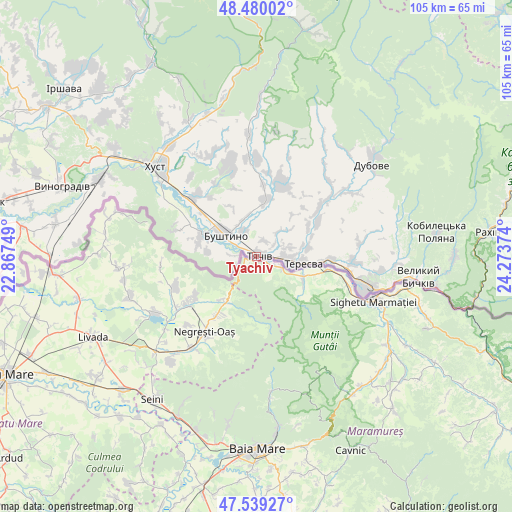
Tyachiv GPS coordinates[2]
48° 0' 42.444" North, 23° 34' 14.196" East
| Map corner | latitude | longitude |
|---|---|---|
| Upper-left | 48.48002°, | 22.86749° |
| Center: | 48.01179°, | 23.57061° |
| Lower-right: | 47.53927°, | 24.27374° |
| Map W x H: | 104.6×104.6 km | = 65×65mi |
| max Lat: | 52.18903° ⇑56.6% North |
| Tyachiv: | 48.01179° |
| min Lat: | ⇓43.4% South 44.39214° |
| min Long | Tyachiv | max Long |
| 22.20555° | 23.57061° | 40.13222° |
| W 4.9%⇐ | ⇒95.1% E |
Elevation
Elevation of Tyachiv is 213 m = 699 ft, and this is 57.2 m = 188 ft above average elevation for this country.
| Max E: |
886 m = 2907 ft | 28.2% |
| Tyachiv | 213 m 699 ft | |
| Avg. | 155.8 m = 511 ft | |
Min E: |
-3 m = -10 ft | 71.8% |
See also: Ukraine elevation on elevation.city.
Geographical zone
Tyachiv is located in North temperate zone (between Tropic of Cancer and the Arctic Circle). Distance of this North polar circle is 2062.8 km =1281.8 mi to North.| Distance of | km | miles | from Tyachiv |
|---|---|---|---|
| North Pole | 4668.7 | 2901 | to North |
| Arctic Circle | 2062.8 | 1281.8 | to North |
| Tropic Cancer | 2732.5 | 1697.9 | to South |
| Equator | 5338.4 | 3317.1 | to South |


Nearby cities:
15 places around Tyachiv: (largest is in red/bold)
• Bushtyno
7.7 km =4.8 mi,  304°
304°
• Drahovo
25 km =15.5 mi,  356°
356°
• Dubove
29.6 km =18.4 mi,  53°
53°
• Horinchovo
30.5 km =19 mi,  340°
340°
• Iza
28.9 km =18 mi,  321°
321°
• Kalyny
26.7 km =16.6 mi,  57°
57°
• Khust
27.4 km =17 mi,  312°
312°
• Kopashnovo
24 km =14.9 mi, 344°
• Kryva
30.6 km =19 mi, 305°
• Lypcha
31 km =19.3 mi,  333°
333°
• Neresnytsya
18.7 km =11.6 mi, 50°
• Nyzhnye Selyshche
22.7 km =14.1 mi, 336°
• Serednye Vodyane
25.5 km =15.8 mi,  97°
97°
• Solotvyno
23.5 km =14.6 mi,  108°
108°
• Vyshkovo
11.9 km =7.4 mi,  290°
290°
Sources, notices
• [Note1] Compared only with cities in Ukraine existing in our database
• [Src1] Map data: © OpenStreetMap contributors (CC-BY-SA)
• [Src2] Other city data from geonames.org with taken over terms of usage.
• [Src3] Geographical zone / Annual Mean Temperature by Robert A. Rohde @ Wikipedia
