Terny geodata
Terny (Donetsk) is a seat of a third-order administrative division; located in Ukraine in Europe/Kiev (GMT+3) time zone. In our database, there are 1661 cities with bigger population. Compared to other cities in Ukraine, 68.3% of cities are located further ↓South; 94.2% of cities are located further ←West and 69.8% of cities have higher elevation than Terny. Note1


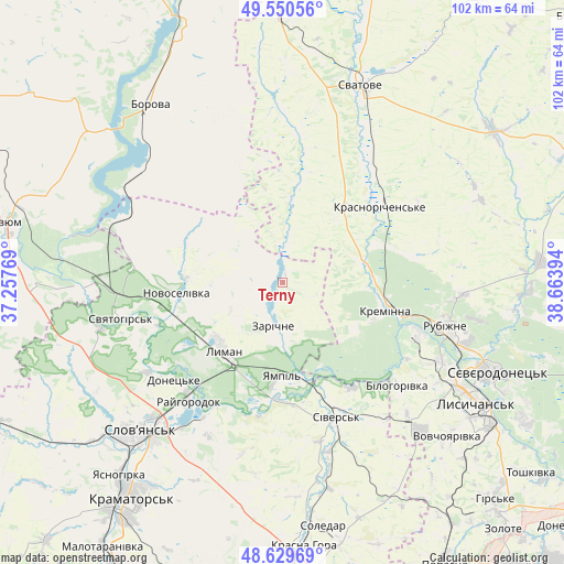
Terny GPS coordinates[2]
49° 5' 32.136" North, 37° 57' 38.916" East
| Map corner | latitude | longitude |
|---|---|---|
| Upper-left | 49.55056°, | 37.25769° |
| Center: | 49.09226°, | 37.96081° |
| Lower-right: | 48.62969°, | 38.66394° |
| Map W x H: | 102.4×102.4 km | = 63.6×63.6mi |
| max Lat: | 52.18903° ⇑31.7% North |
| Terny: | 49.09226° |
| min Lat: | ⇓68.3% South 44.39214° |
| min Long | Terny | max Long |
| 22.20555° | 37.96081° | 40.13222° |
| W 94.2%⇐ | ⇒5.8% E |
Elevation
Elevation of Terny is 76 m = 249 ft, and this is 79.8 m = 262 ft below average elevation for this country.
| Max E: |
886 m = 2907 ft | 69.8% |
| Avg. | 155.8 m = 511 ft | |
| Terny | 76 m = 249 ft | |
Min E: |
-3 m = -10 ft | 30.2% |
See also: Ukraine elevation on elevation.city.
Geographical zone
Terny is located in North temperate zone (between Tropic of Cancer and the Arctic Circle). Distance of this North polar circle is 1942.6 km =1207.1 mi to North.| Distance of | km | miles | from Terny |
|---|---|---|---|
| North Pole | 4548.5 | 2826.3 | to North |
| Arctic Circle | 1942.6 | 1207.1 | to North |
| Tropic Cancer | 2852.6 | 1772.5 | to South |
| Equator | 5458.5 | 3391.8 | to South |


Nearby cities:
15 places around Terny: (largest is in red/bold)
• Bilohorivka
28 km =17.4 mi,  131°
131°
• Drobysheve
17.8 km =11.1 mi,  251°
251°
• Kreminna
19.3 km =12 mi,  104°
104°
• Kryva Luka
24.6 km =15.3 mi,  189°
189°
• Lyman
16.3 km =10.1 mi,  225°
225°
• Novoselivka
19.5 km =12.1 mi,  262°
262°
• Pryvillya
26.5 km =16.5 mi,  108°
108°
• Rubizhne
31.8 km =19.8 mi, 106°
• Serebryanka
23.1 km =14.4 mi,  146°
146°
• Sivers’k
27 km =16.8 mi,  157°
157°
• Studenok
34.5 km =21.4 mi,  269°
269°
• Svyatogorsk
29.5 km =18.3 mi, 257°
• Yampil’
17.4 km =10.8 mi,  181°
181°
• Yats’kivka
33.3 km =20.7 mi,  287°
287°
• Zarichne
7.9 km =4.9 mi,  195°
195°
Sources, notices
• [Note1] Compared only with cities in Ukraine existing in our database
• [Src1] Map data: © OpenStreetMap contributors (CC-BY-SA)
• [Src2] Other city data from geonames.org with taken over terms of usage.
• [Src3] Geographical zone / Annual Mean Temperature by Robert A. Rohde @ Wikipedia
