Pryvillya geodata
Pryvillya (Luhansk) is a populated place; located in Ukraine in Europe/Zaporozhye (GMT+3) time zone. With population of 8,669 people, there are 408 cities with bigger population in this country. Compared to other cities in Ukraine, 66.7% of cities are located further ↓South; 96.2% of cities are located further ←West and 71.4% of cities have higher elevation than Pryvillya. Note1


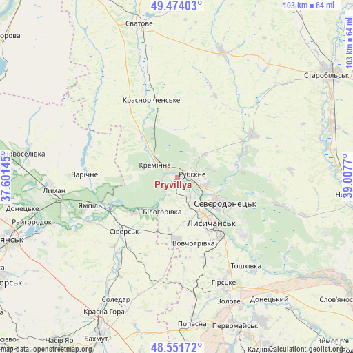
Pryvillya GPS coordinates[2]
49° 0' 54.036" North, 38° 18' 16.452" East
| Map corner | latitude | longitude |
|---|---|---|
| Upper-left | 49.47403°, | 37.60145° |
| Center: | 49.01501°, | 38.30457° |
| Lower-right: | 48.55172°, | 39.0077° |
| Map W x H: | 102.6×102.5 km | = 63.8×63.7mi |
| max Lat: | 52.18903° ⇑33.3% North |
| Pryvillya: | 49.01501° |
| min Lat: | ⇓66.7% South 44.39214° |
| min Long | Pryvillya | max Long |
| 22.20555° | 38.30457° | 40.13222° |
| W 96.2%⇐ | ⇒3.8% E |
Elevation
Elevation of Pryvillya is 71 m = 233 ft, and this is 84.8 m = 278 ft below average elevation for this country.
| Max E: |
886 m = 2907 ft | 71.4% |
| Avg. | 155.8 m = 511 ft | |
| Pryvillya | 71 m = 233 ft | |
Min E: |
-3 m = -10 ft | 28.6% |
See also: Ukraine elevation on elevation.city.
Geographical zone
Pryvillya is located in North temperate zone (between Tropic of Cancer and the Arctic Circle). Distance of this North polar circle is 1951.2 km =1212.4 mi to North.| Distance of | km | miles | from Pryvillya |
|---|---|---|---|
| North Pole | 4557.1 | 2831.6 | to North |
| Arctic Circle | 1951.2 | 1212.4 | to North |
| Tropic Cancer | 2844 | 1767.2 | to South |
| Equator | 5450 | 3386.5 | to South |


Nearby cities:
15 places around Pryvillya: (largest is in red/bold)
• Bilohorivka
10.8 km =6.7 mi,  202°
202°
• Hirs’ke
34.2 km =21.3 mi,  155°
155°
• Kreminna
7.4 km =4.6 mi,  301°
301°
• Kryva Luka
33.2 km =20.6 mi,  241°
241°
• Lysychans’k
15.8 km =9.8 mi,  140°
140°
• Met’olkine
20.5 km =12.7 mi,  117°
117°
• Rubizhne
5.5 km =3.4 mi,  93°
93°
• Serebryanka
16.3 km =10.1 mi,  229°
229°
• Sivers’k
22.2 km =13.8 mi,  222°
222°
• Syevyerodonets’k
15.5 km =9.6 mi, 118°
• Terny
26.5 km =16.5 mi,  288°
288°
• Toshkivka
33 km =20.5 mi, 142°
• Voronove
23.5 km =14.6 mi, 123°
• Yampil’
26.9 km =16.7 mi,  250°
250°
• Zarichne
27.2 km =16.9 mi,  271°
271°
Sources, notices
• [Note1] Compared only with cities in Ukraine existing in our database
• [Src1] Map data: © OpenStreetMap contributors (CC-BY-SA)
• [Src2] Other city data from geonames.org with taken over terms of usage.
• [Src3] Geographical zone / Annual Mean Temperature by Robert A. Rohde @ Wikipedia
