Kreminna geodata
Kreminna (Luhansk) is a seat of a second-order administrative division; located in Ukraine in Europe/Zaporozhye (GMT+3) time zone. With population of 23,538 people, there are 176 cities with bigger population in this country. Compared to other cities in Ukraine, 67.6% of cities are located further ↓South; 95.6% of cities are located further ←West and 74.5% of cities have higher elevation than Kreminna. Note1


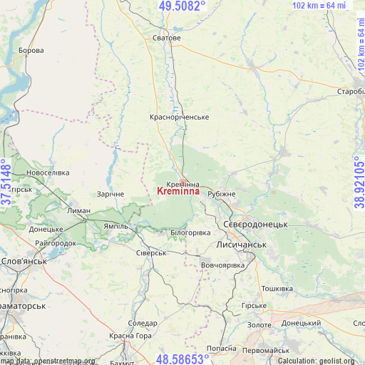
Kreminna GPS coordinates[2]
49° 2' 58.2" North, 38° 13' 4.512" East
| Map corner | latitude | longitude |
|---|---|---|
| Upper-left | 49.5082°, | 37.5148° |
| Center: | 49.0495°, | 38.21792° |
| Lower-right: | 48.58653°, | 38.92105° |
| Map W x H: | 102.5×102.5 km | = 63.7×63.7mi |
| max Lat: | 52.18903° ⇑32.4% North |
| Kreminna: | 49.0495° |
| min Lat: | ⇓67.6% South 44.39214° |
| min Long | Kreminna | max Long |
| 22.20555° | 38.21792° | 40.13222° |
| W 95.6%⇐ | ⇒4.4% E |
Elevation
Elevation of Kreminna is 62 m = 203 ft, and this is 93.8 m = 308 ft below average elevation for this country.
| Max E: |
886 m = 2907 ft | 74.5% |
| Avg. | 155.8 m = 511 ft | |
| Kreminna | 62 m = 203 ft | |
Min E: |
-3 m = -10 ft | 25.5% |
See also: Ukraine elevation on elevation.city.
Geographical zone
Kreminna is located in North temperate zone (between Tropic of Cancer and the Arctic Circle). Distance of this North polar circle is 1947.4 km =1210.1 mi to North.| Distance of | km | miles | from Kreminna |
|---|---|---|---|
| North Pole | 4553.3 | 2829.3 | to North |
| Arctic Circle | 1947.4 | 1210.1 | to North |
| Tropic Cancer | 2847.9 | 1769.6 | to South |
| Equator | 5453.8 | 3388.8 | to South |


Nearby cities:
15 places around Kreminna: (largest is in red/bold)
• Bilohorivka
14 km =8.7 mi,  170°
170°
• Drobysheve
35.6 km =22.1 mi,  268°
268°
• Kryva Luka
30.2 km =18.8 mi,  229°
229°
• Lyman
31.1 km =19.3 mi,  257°
257°
• Lysychans’k
22.9 km =14.2 mi,  134°
134°
• Met’olkine
27.8 km =17.3 mi,  118°
118°
• Pryvillya
7.4 km =4.6 mi, 121°
• Rubizhne
12.5 km =7.8 mi,  109°
109°
• Serebryanka
15.7 km =9.8 mi,  202°
202°
• Sivers’k
22 km =13.7 mi, 202°
• Syevyerodonets’k
22.9 km =14.2 mi, 119°
• Terny
19.3 km =12 mi,  284°
284°
• Voronove
30.9 km =19.2 mi, 123°
• Yampil’
22.9 km =14.2 mi,  236°
236°
• Zarichne
21.1 km =13.1 mi, 262°
Sources, notices
• [Note1] Compared only with cities in Ukraine existing in our database
• [Src1] Map data: © OpenStreetMap contributors (CC-BY-SA)
• [Src2] Other city data from geonames.org with taken over terms of usage.
• [Src3] Geographical zone / Annual Mean Temperature by Robert A. Rohde @ Wikipedia
