Drobysheve geodata
Drobysheve (Donetsk) is a seat of a third-order administrative division; located in Ukraine in Europe/Kiev (GMT+3) time zone. In our database, there are 1661 cities with bigger population. Compared to other cities in Ukraine, 67.3% of cities are located further ↓South; 93.4% of cities are located further ←West and 62.1% of cities have higher elevation than Drobysheve. Note1


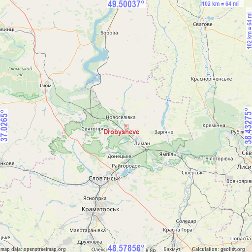
Drobysheve GPS coordinates[2]
49° 2' 29.76" North, 37° 43' 46.632" East
| Map corner | latitude | longitude |
|---|---|---|
| Upper-left | 49.50037°, | 37.0265° |
| Center: | 49.0416°, | 37.72962° |
| Lower-right: | 48.57856°, | 38.43275° |
| Map W x H: | 102.5×102.5 km | = 63.7×63.7mi |
| max Lat: | 52.18903° ⇑32.7% North |
| Drobysheve: | 49.0416° |
| min Lat: | ⇓67.3% South 44.39214° |
| min Long | Drobysheve | max Long |
| 22.20555° | 37.72962° | 40.13222° |
| W 93.4%⇐ | ⇒6.6% E |
Elevation
Elevation of Drobysheve is 100 m = 328 ft, and this is 55.8 m = 183 ft below average elevation for this country.
| Max E: |
886 m = 2907 ft | 62.1% |
| Avg. | 155.8 m = 511 ft | |
| Drobysheve | 100 m = 328 ft | |
Min E: |
-3 m = -10 ft | 37.9% |
See also: Ukraine elevation on elevation.city.
Geographical zone
Drobysheve is located in North temperate zone (between Tropic of Cancer and the Arctic Circle). Distance of this North polar circle is 1948.3 km =1210.6 mi to North.| Distance of | km | miles | from Drobysheve |
|---|---|---|---|
| North Pole | 4554.1 | 2829.8 | to North |
| Arctic Circle | 1948.3 | 1210.6 | to North |
| Tropic Cancer | 2847 | 1769 | to South |
| Equator | 5452.9 | 3388.3 | to South |


Nearby cities:
15 places around Drobysheve: (largest is in red/bold)
• Chervonyy Oskil
26.9 km =16.7 mi,  304°
304°
• Kramators’k
37.6 km =23.4 mi,  199°
199°
• Kreminna
35.6 km =22.1 mi,  88°
88°
• Kryva Luka
22.6 km =14 mi,  145°
145°
• Lyman
7.9 km =4.9 mi,  138°
138°
• Novoselivka
4 km =2.5 mi,  321°
321°
• Serebryanka
32.6 km =20.3 mi,  114°
114°
• Sivers’k
33.3 km =20.7 mi,  125°
125°
• Sloviansk
21.1 km =13.1 mi, 202°
• Studenok
18.5 km =11.5 mi,  287°
287°
• Svyatogorsk
11.9 km =7.4 mi,  265°
265°
• Terny
17.8 km =11.1 mi,  71°
71°
• Yampil’
20.3 km =12.6 mi, 125°
• Yats’kivka
21.5 km =13.4 mi, 315°
• Zarichne
14.9 km =9.3 mi,  97°
97°
Sources, notices
• [Note1] Compared only with cities in Ukraine existing in our database
• [Src1] Map data: © OpenStreetMap contributors (CC-BY-SA)
• [Src2] Other city data from geonames.org with taken over terms of usage.
• [Src3] Geographical zone / Annual Mean Temperature by Robert A. Rohde @ Wikipedia
