Novoselivka geodata
Novoselivka (Donetsk) is a seat of a third-order administrative division; located in Ukraine in Europe/Kiev (GMT+3) time zone. In our database, there are 1661 cities with bigger population. Compared to other cities in Ukraine, 67.8% of cities are located further ↓South; 93.3% of cities are located further ←West and 60.8% of cities have higher elevation than Novoselivka. Note1


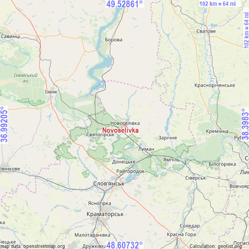
Novoselivka GPS coordinates[2]
49° 4' 12.36" North, 37° 41' 42.612" East
| Map corner | latitude | longitude |
|---|---|---|
| Upper-left | 49.52861°, | 36.99205° |
| Center: | 49.0701°, | 37.69517° |
| Lower-right: | 48.60732°, | 38.3983° |
| Map W x H: | 102.4×102.4 km | = 63.6×63.6mi |
| max Lat: | 52.18903° ⇑32.2% North |
| Novoselivka: | 49.0701° |
| min Lat: | ⇓67.8% South 44.39214° |
| min Long | Novoselivka | max Long |
| 22.20555° | 37.69517° | 40.13222° |
| W 93.3%⇐ | ⇒6.7% E |
Elevation
Elevation of Novoselivka is 103 m = 338 ft, and this is 52.8 m = 173 ft below average elevation for this country.
| Max E: |
886 m = 2907 ft | 60.8% |
| Avg. | 155.8 m = 511 ft | |
| Novoselivka | 103 m = 338 ft | |
Min E: |
-3 m = -10 ft | 39.2% |
See also: Ukraine elevation on elevation.city.
Geographical zone
Novoselivka is located in North temperate zone (between Tropic of Cancer and the Arctic Circle). Distance of this North polar circle is 1945.1 km =1208.6 mi to North.| Distance of | km | miles | from Novoselivka |
|---|---|---|---|
| North Pole | 4551 | 2827.9 | to North |
| Arctic Circle | 1945.1 | 1208.6 | to North |
| Tropic Cancer | 2850.2 | 1771 | to South |
| Equator | 5456.1 | 3390.3 | to South |


Nearby cities:
15 places around Novoselivka: (largest is in red/bold)
• Borova
34.6 km =21.5 mi,  351°
351°
• Chervonyy Oskil
23 km =14.3 mi,  301°
301°
• Drobysheve
4 km =2.5 mi,  141°
141°
• Izyum
36 km =22.4 mi, 295°
• Kryva Luka
26.6 km =16.5 mi,  145°
145°
• Lyman
12 km =7.5 mi, 139°
• Serebryanka
36.2 km =22.5 mi,  117°
117°
• Sivers’k
37.2 km =23.1 mi,  127°
127°
• Sloviansk
23.3 km =14.5 mi,  194°
194°
• Studenok
15.3 km =9.5 mi,  278°
278°
• Svyatogorsk
10.2 km =6.3 mi,  246°
246°
• Terny
19.5 km =12.1 mi,  82°
82°
• Yampil’
24.2 km =15 mi, 128°
• Yats’kivka
17.5 km =10.9 mi,  314°
314°
• Zarichne
18 km =11.2 mi,  106°
106°
Sources, notices
• [Note1] Compared only with cities in Ukraine existing in our database
• [Src1] Map data: © OpenStreetMap contributors (CC-BY-SA)
• [Src2] Other city data from geonames.org with taken over terms of usage.
• [Src3] Geographical zone / Annual Mean Temperature by Robert A. Rohde @ Wikipedia
